
Max. length 12 km (7.5 mi) Surface area 22 km (8.5 sq mi) Area 22 km² Length 12 km | Max. width 7 km (4.3 mi) Shore length 55 km (34 mi) Surface elevation 185 m Width 7 km | |
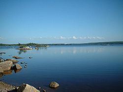 | ||
Gaspereau Lake is a lake in Kings County, Nova Scotia, Canada, about 10 km south of the town of Kentville, Nova Scotia on the South Mountain. It is the largest lake in Kings County, and the fifth largest lake in Nova Scotia. The lake is shallow with dozens of forested islands and hundreds of rocky islets (skerries).
Map of Gaspereau Lake, Nova Scotia, Canada
The water level of the lake is controlled by Nova Scotia Power. At the natural outlet to the Gaspereau River, in the north-east corner of the lake, there is a control dam and fish ladder. Another control dam at the south-east corner of the lake controls outflow to a canal which diverts water to Hydroelectricity stations on the lower sections of the Gaspereau River system.
In late spring the namesake fish, gaspereau(Alewife) migrate from the ocean up the Gaspereau River, and spawn in the shallow waters of Gaspereau Lake.