
Area 179 km² | Administrative divisions 7 administrative dong Local time Friday 6:13 PM | |
 | ||
Website Gangseo District Office Weather 12°C, Wind W at 11 km/h, 36% Humidity Points of interest LetsRun Park Busan–Gyeongnam, Cheonseongjinseong, Yeondaebong | ||
Gangseo District (literally west of river district) is a gu on the west side of Nakdong River in Busan, South Korea. It has an area of 179.05 km², and a population of about 66,000; it has a lower population density than Gijang county of Busan. Gangseo-gu was part of Buk-gu from its creation in 1978 to 1989 when it became an independent gu.
Contents
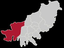
Map of Gangseo-gu, Busan, South Korea
Gangseo-gu is the westernmost gu in Busan and it shares a common borders with Gimhae on its north-west side and Jinhae-gu, Changwon on its south-west side.
Gangseo-gu is the birthplace of the Gaya civilization.
Gimhae International Airport, Heungguk Temple, Myeongwol Temple, as well as the Eulsukdo bird sanctuary are located in Gangseo-gu.
Administrative divisions
Gangseo-gu is divided into 22 legal dong. They have been grouped together to from only 7 administrative dong, as follows: