
Hangul 혼일강리역대국도지도 Hangul 강리도 | Hanja 混一疆理歷代國都之圖 Hanja 疆理圖 | |
 | ||
Revised Romanization Honil Gangni Yeokdae Gukdo Ji Do McCune–Reischauer Honil Kangni Yŏktae Kukto Chi To | ||
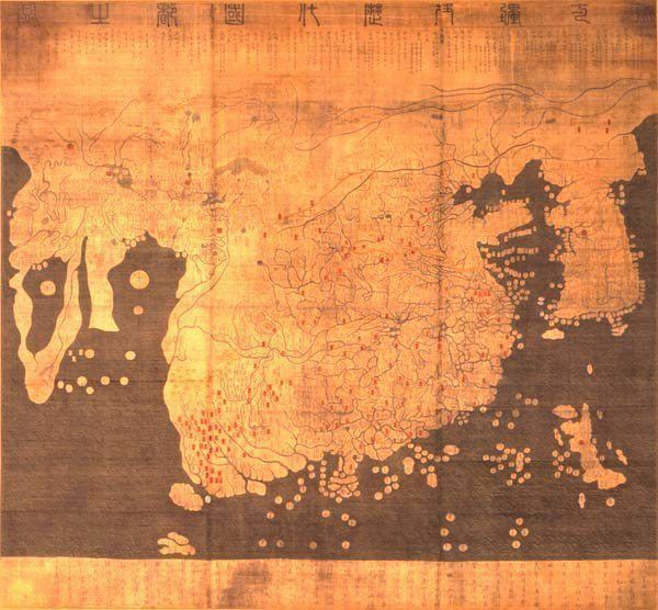
The Honil Gangni Yeokdae Gukdo Ji Do ("Map of Integrated Lands and Regions of Historical Countries and Capitals."), often abbreviated as Kangnido, is a world map created in Korea, produced by Yi Hoe and Kwon Kun in 1402.
Contents
The Kangnido is one of the oldest surviving world maps from East Asia, along with the (ca. 1398) Chinese Da Ming Hun Yi Tu. Surviving copies of both the Kangnido and the Da Ming Hun Yi Tu all bear later revisions, and the original, unrevised forms of both maps are uncertain. Nevertheless, the surviving copies of the Kangnido constitute one of the most important materials for reconstructing the original form of the 14th-century Chinese map. As a world map, it reflects the geographic knowledge of China during the Mongol Empire when geographical information about Western countries became available via Islamic geographers.
It depicts the general form of the Old World, from Africa and Europe in the west to Japan in the east. Although, overall, it is less geographically accurate than its Chinese cousin, most obviously in the depiction of rivers and small islands, it does feature some improvements (particularly the depictions of Korea and Japan, and a less cramped version of Africa).
Manuscripts
Only two copies of the map are known today. Both have been preserved in Japan and show later modifications.
The map currently in Ryūkoku University (hereafter, Ryūkoku copy) has gathered scholarly attention since the early 20th century. It is 158 cm by 163 cm, painted on silk. It is presumed that the Ryūkoku copy was created in Korea but it is not clear when the copy was brought to Japan. One claims that it was purchased by Ōtani Kōzui and others assume that it was obtained during the invasion of Korea (1592-1598) and given to the West Honganji temple by Toyotomi Hideyoshi. It contains some place names of Korea that are newer than 1402, suggesting that the Ryūkoku copy was partially modified from the 1402 original around the 1470s and 1480s.
Another copy (Honkōji copy) was discovered in the Honkōji temple of Shimabara, Nagasaki in 1988. It is 220 cm by 280 cm, much larger than the Ryūkoku copy, and painted on paper. It seems that the Honkōji copy was created in Japan during the Edo period. The place names of Korea suggests that it was revised around the 1560s.
There are two copies of maps in Japan that are related to the map. One (Honmyōji copy) housed in the Honmyōji temple of Kumamoto is known as the "Map of the Great Ming" (大明國地圖). The other (Tenri copy) at Tenri University has no title and is tentatively called by a similar name (大明國圖). They are considered to be later adaptations of the original. The most important change is that place names of China are updated to those of the Ming Dynasty while the original showed administrative divisions of the Mongol Yuan Dynasty.
Based on a legend of the temple, it has been assumed naively that the Honmyōji copy was given to Katō Kiyomasa, the ruler of Kumamoto, by Toyotomi Hideyoshi in preparation for the Korean campaigns. However, the Seonjo Sillok of Korea reports that in 1593 the son of a Korean official who had surrendered to Katō copied and offered map(s) of China and Korea to him. This may refer to the extant Honmyōji map.
Importance in Korea
This map originated from a historical setting of the Mongol Empire, which connected the western Islamic world with the Chinese sphere. The Mongol Empire demonstrated the conquest of the world by publishing treatise on geography and world maps. Their attempt enabled the integration of Islamic science and traditional Chinese knowledge. Note that the Chinese source maps were of "consumer use." In other words, they were not created by the empire for itself. It is presumed that the Mongol government gathered much more detailed information that was not disclosed to the public.
The Chinese source maps were created by and circulated among literati of southern China, especially those in Qingyuan-lu (Ningbo). Qingjun, who was from neighboring Taizhou, created the historical map of Hunyi Jiangli Tu when he stayed in Qingyuan. Wu Sidao, who left an important bibliographic clue, was also from Qingyuan. In addition, Qingyuan-lu was one of the most important seaports from which the sea routes were extended to Fuzhou and Guangzhou, and Southeast Asia, Japan and Korea.
It is possible that these maps were available in Korea during the Mongol era. Korea, at the time under the Goryeo Dynasty (918-1392), was closely integrated into the Mongol Empire as a "son-in-law" (駙馬) state. One supporting fact is recorded in the Goryeo-sa: Na Heung-yu (羅興儒) created a historical map based on maps of China and Korea, and dedicated it to King Gongmin (r. 1352-1374). Note that Gwon Geun served to the king as bichigechi (secretary).
Earlier studies presumed that the two Chinese source maps had been obtained during Kim Sa-hyeong's diplomatic trip to Ming China in 1399 although there is no literary evidence for his acquisition. It is more plausible that these maps came to Korea in different times since Gwon Geun's preface implies that Korean officials picked out the two maps for their excellency from among various sources, maybe including Wu Sidao's combined map.
Japanese scholar Miya Noriko presumes that the year 1402 was a landmark for the reigning King Taejong of the newly founded Joseon Dynasty. After a bloody succession struggle, Taejong ascended to the throne in 1400. In 1401, he was officially recognized as King of Joseon by the Chinese Emperor for the first time in the dynasty's history. In the 6th month of 1402, Yi Hoe's map of Korea was offered in a ceremony to celebrate his birthday. Then the project to combine it with Chinese and Japanese maps reportedly started in the summer (4th-6th months). This would be of symbolic significance in demonstrating royal power. This hypothesis also explains the factual error about the map of Japan. It was during the reigns of Taejo (1st king) and Jeongjong (2nd) that the map was obtained in Japan, but the date was altered to Taejong's reign.
Oddly enough, the Annals of Joseon Dynasty never mentions the map although it was obviously a national project. Another interesting fact is that this map uses the Ming Chinese era name Jianwen. After the Jianwen Emperor lost to Zhu Di in a civil war, the new emperor banned the use of the era name Jianwen in the 10th month of 1402. Thus the map should have used the era name Hongwu, not Jianwen. However, the era name Jianwen can be found even on the later Ryūkoku and Honkōji copies. This suggests that the Kangnido was never disclosed to the Chinese.
This map demonstrates the cartographic stagnation in the post-Mongol era. The maps of common use were transformed into a symbol of national prestige and overshadowed by secrecy. As the extant copies show, Korean officials regularly updated the map by conducting land surveys and collecting maps from surrounding countries. Geographic information about the West was, however, not updated until the introduction of European knowledge in the 16-17th centuries.