
 | ||
The Gall–Peters projection, named after James Gall and Arno Peters, is one specialization of a configurable equal-area map projection known as the equal-area cylindric or cylindrical equal-area projection. It achieved considerable notoriety in the late 20th century as the centerpiece of a controversy about the political implications of map design.
Contents
- Formula
- Simplified formula
- Discussion
- Origins and naming
- Peters World Map
- Controversy
- In popular culture
- References
Maps based on the projection are promoted by UNESCO, and they are also widely used by British schools.
Formula
The projection is conventionally defined as:
where λ is the longitude from the central meridian in degrees, φ is the latitude, and R is the radius of the globe used as the model of the earth for projection. For longitude given in radians, remove the π/180° factors.
Simplified formula
Stripping out unit conversion and uniform scaling, the formulae may be written:
where λ is the longitude from the central meridian (in radians), φ is the latitude, and R is the radius of the globe used as the model of the earth for projection. Hence the sphere is mapped onto the vertical cylinder, and the cylinder is stretched to double its length. The stretch factor, 2 in this case, is what distinguishes the variations of cylindric equal-area projection.
Discussion
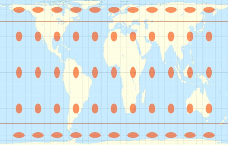
The various specializations of the cylindric equal-area projection differ only in the ratio of the vertical to horizontal axis. This ratio determines the standard parallel of the projection, which is the parallel at which there is no distortion and along which distances match the stated scale. There are always two standard parallels on the cylindric equal-area projection, each at the same distance north and south of the equator. The standard parallels of the Gall–Peters are 45° N and 45° S. Several other specializations of the equal-area cylindric have been described, promoted, or otherwise named.
Origins and naming
The Gall–Peters projection was first described in 1855 by clergyman James Gall, who presented it along with two other projections at the Glasgow meeting of the British Association for the Advancement of Science (the BA). He gave it the name "orthographic" (no relation to the Orthographic projection) and formally published his work in 1885 in the Scottish Geographical Magazine.
The name "Gall–Peters projection" seems to have been used first by Arthur H. Robinson in a pamphlet put out by the American Cartographic Association in 1986. Before 1973 it had been known, when referred to at all, as the "Gall orthographic" or "Gall's orthographic." Most Peters supporters refer to it only as the "Peters projection." During the years of controversy the cartographic literature tended to mention both attributions, settling on one or the other for the purposes of the article. In recent years "Gall–Peters" seems to dominate.
Peters World Map
In 1967 Arno Peters, a German filmmaker, devised a map projection identical to Gall's orthographic projection and presented it in 1973 as a "new invention." He promoted it as a superior alternative to the Mercator projection, which was suited to navigation but also used commonly in world maps. The Mercator projection increasingly inflates the sizes of regions according to their distance from the equator. This inflation results, for example, in a representation of Greenland that is larger than Africa, which has a geographic area 14 times greater than Greenland's. Since much of the technologically underdeveloped world lies near the equator, these countries appear smaller on a Mercator and therefore, according to Peters, seem less significant. On Peters's projection, by contrast, areas of equal size on the globe are also equally sized on the map. By using his "new" projection, poorer, less powerful nations could be restored to their rightful proportions. This reasoning has been picked up by many educational and religious bodies, leading to adoption of the Gall–Peters projection among some socially concerned groups, including Oxfam, National Council of Churches, New Internationalist magazine, and the Mennonite Central Committee. However, Peters's choice of 45° N/S for the standard parallels means that the regions displayed with highest accuracy include Europe and the US, and not the tropics.
Peters's original description of the projection for his map contained a geometric error that, taken literally, implies standard parallels of 46°02′ N/S. However the text accompanying the description made it clear that he had intended the standard parallels to be 45° N/S, making his projection identical to Gall's orthographic. In any case, the difference is negligible in a world map.
Controversy
At first, the cartographic community largely ignored Peters's foray into cartography. The preceding century had already witnessed many campaigns for new projections with little visible result. Just twenty years earlier, for example, Trystan Edwards described and promoted his own eponymous projection, disparaging the Mercator, and recommending his projection as the solution. Peters's projection differed from Edwards's only in height-to-width ratio. More problematic, Peters's projection was identical to one that was already over a century old, though he probably did not realize it. That projection—Gall's orthographic—passed unnoticed when it was announced in 1855.
Beyond the lack of novelty in the projection itself, the claims Peters made about the projection were also familiar to cartographers. Just as in the case of Peters, earlier projections generally were promoted as alternatives to the Mercator. Inappropriate use of the Mercator projection in world maps and the size disparities figuring prominently in Peters's arguments against the Mercator projection had been remarked upon for centuries and quite commonly in the 20th century. As early as 1943, Stewart notes this phenomenon and compares the quest for the perfect projection to "squaring the circle or making pi come out even" because the mathematics that governs map projections just does not permit development of a map projection that is objectively significantly better than the hundreds already devised. Even Peters's politicized interpretation of the common use of Mercator was nothing new, with Kelloway's 1946 text mentioning a similar controversy.
Cartographers had long despaired over publishers' inapt use of the Mercator. A 1943 New York Times editorial stated that "...The time has come to discard [the Mercator] for something that represents the continents and directions less deceptively... Although its usage... has diminished... it is still highly popular as a wall map apparently in part because, as a rectangular map, it fills a rectangular wall space with more map, and clearly because its familiarity breeds more popularity." Because of the lack of novelty both in the projection Peters devised and in the rhetoric surrounding its promotion, the cartographic community had no reason to think Peters would succeed any more than Edwards or his predecessors had.
Peters, however, launched his campaign in a different world from that of Edwards. He announced his map at a time when themes of social justice resonated strongly in academia and politics. Suggesting cartographic imperialism, Peters found ready audiences. The campaign was bolstered by the claim that the Peters projection was the only "area-correct" map. Other claims included "absolute angle conformality," "no extreme distortions of form," and "totally distance-factual."
All of those claims were erroneous. Some of the oldest projections are equal-area (the sinusoidal projection is also known as the "Mercator equal-area projection"), and hundreds have been described, refuting any implication that Peters's map is special in that regard. In any case, Mercator was not the pervasive projection Peters made it out to be: a wide variety of projections has always been used in world maps. Peters's chosen projection suffers extreme distortion in the polar regions, as any cylindrical projection must, and its distortion along the equator is considerable. Several scholars have remarked on the irony of the projection's undistorted presentation of the mid latitudes, including Peters's native Germany, at the expense of the low latitudes, which host more of the technologically underdeveloped nations. The claim of distance fidelity is particularly problematic: Peters's map lacks distance fidelity everywhere except along the 45th parallels north and south, and then only in the direction of those parallels. No world projection is good at preserving distances everywhere; Peters's and all other cylindric projections are especially bad in that regard because east-west distances inevitably balloon toward the poles.
The cartographic community met Peters's 1973 press conference with amusement and mild exasperation, but little activity beyond a few articles commenting on the technical aspects of Peters's claims. In the ensuing years, however, it became clear that Peters and his map were no flash in the pan. By 1980 many cartographers had turned overtly hostile to his claims. In particular, Peters writes in The New Cartography,
Philosophers, astronomers, historians, popes and mathematicians have all drawn global maps long before cartographers as such existed. Cartographers appeared in the "Age of Discovery", which developed into the Age of European Conquest and Exploitation and took over the task of making maps.
By the authority of their profession they have hindered its development. Since Mercator produced his global map over four hundred years ago for the age of Europeans world domination, cartographers have clung to it despite its having been long outdated by events. They have sought to render it topical by cosmetic corrections.
...The European world concept, as the last expression of a subjective global view of primitive peoples, must give way to an objective global concept.
The cartographic profession is, by its retention of old precepts based on the Eurocentric global concept, incapable of developing this egalitarian world map which alone can demonstrate the parity of all peoples of the earth.
This attack galled the cartographic community. Their most emphatic refutation of Peters’s assertions was the long list of cartographers who, over the preceding century, had formally expressed frustration at publishers’ overuse of the Mercator, as noted above. Many of those cartographers had already developed projections they explicitly promoted as alternatives to the Mercator, including the most influential American cartographers of the twentieth century: John Paul Goode (Goode homolosine projection), Erwin Raisz (Armadillo projection), and Arthur H. Robinson (Robinson projection). Hence the cartographic community viewed Peters’s narrative as ahistorical and mean-spirited.
The two camps never made any real attempts toward reconciliation. The Peters camp largely ignored the protests of the cartographers. Peters maintained there should be "one map for one world"—his—and did not acknowledge the prior art of Gall until the controversy had largely run its course, late in his life. While Peters likely reinvented the projection independently, his unscholarly conduct and refusal to engage the cartographic community undoubtedly contributed to the polarization and impasse.
Frustrated by some very visible successes and mounting publicity stirred up by the industry that had sprung up around the Peters map, the cartographic community began to plan more coordinated efforts to restore balance, as they saw it. The 1980s saw a flurry of literature directed against the Peters phenomenon. Though Peters's map was not singled out, the controversy motivated the American Cartographic Association (now Cartography and Geographic Information Society) to produce a series of booklets (including Which Map Is Best) designed to educate the public about map projections and distortion in maps. In 1989 and 1990, after some internal debate, seven North American geographic organizations adopted the following resolution, which rejected all rectangular world maps, a category that includes both the Mercator and the Gall–Peters projections:
WHEREAS, the earth is round with a coordinate system composed entirely of circles, and
WHEREAS, flat world maps are more useful than globe maps, but flattening the globe surface necessarily greatly changes the appearance of Earth's features and coordinate systems, and
WHEREAS, world maps have a powerful and lasting effect on people's impressions of the shapes and sizes of lands and seas, their arrangement, and the nature of the coordinate system, and
WHEREAS, frequently seeing a greatly distorted map tends to make it "look right,"
One map society, the North American Cartographic Information Society (NACIS), declined to endorse the 1989 resolution, although no reasons were given.
The geographic and cartographic communities did not unanimously disparage the Peters World Map. Some cartographers, including J. Brian Harley, have credited the Peters phenomenon with demonstrating the social implications of map projections, at the very least. Crampton sees the condemnation from the cartographic community as reactionary and perhaps demonstrative of immaturity in the profession, given that all maps are political. Denis Wood sees the map as one of many useful tools. Lastly, Terry Hardaker of Oxford Cartographers Limited, sympathetic to Peters's mission, became the map's official cartographer when Peters, overwhelmed by the technical aspects of cartography, sought to pass on those responsibilities.