
Country Spain Highest elevation 326 m (1,070 ft) Area 31.66 km² Population 29,351 (2014) | Autonomous community Basque Country Elevation 60 m (200 ft) Lowest elevation 48 m (157 ft) Local time Thursday 10:05 PM | |
 | ||
Weather 11°C, Wind E at 2 km/h, 91% Humidity | ||
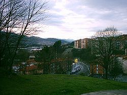
Galdakao is a town and municipality located in the province of Biscay, in the autonomous community of Basque Country, northern Spain.
Contents
Map of Galdakao, Biscay, Spain
It is located in the Greater Bilbao, in the valley of the Ibaizabal river, near the Ganguren mountain range. It is surrounded by some summits such as Arrezurriaga (329 m), Txispamendi (221 m) and Santa Maria (476 m) in the north and Upo (556 m) and Mandoia (640 m) in the south.
It is conterminous with Zamudio, Lezama and Larrabetzu in the north, with Zaratamo and Zeberio in the south, with Amorebieta, Lemona and Bedia in the east and with Etxebarri and Basauri in the west.
Neighbourhoods
References
Galdakao Wikipedia(Text) CC BY-SA