
COSPAR ID 1975-027A Website ilrs.gsfc.nasa.gov | SATCAT no. 7734 Spacecraft type GEOS | |
 | ||
GEOS-3, or Geodynamics Experimental Ocean Satellite 3, or GEOS-C, was the third and final satellite as part of NASA's Geodetic Earth Orbiting Satellite/Geodynamics Experimental Ocean Satellite program (NGSP) to better understand and test satellite tracking systems. For GEOS missions 1 and 2, GEOS stands for Geodetic Earth Orbiting Satellite; this was changed to Geodynamics Experimental Ocean Satellite for GEOS-3.
Contents
Introduction
The satellite mission was designed to further an understanding of the earth’s gravitational field, size and shape of the terrestrial geoid, deep ocean tides, sea state, current structure, crustal structure, solid earth dynamics, and remote sensing technology. Jerome Rosenburg at NASA Headquarters initiated the GEOS-3 project in 1970. The project was to serve as a stepping stone between the GEOS program and the emerging NASA Earth and Ocean Physics Application Program. GEOS-1 and GEOS-2 had provided useful information about the structure of the earth’s gravitational field, but new technology was deemed necessary to gain a further understanding. The project was initially cancelled due to budgetary concerns after an initial 1-year study, but was re-instated in late 1971. The satellite was launched in April 9, 1975 and remained operational until late July 1979.
Instruments
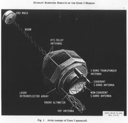
The following is a list of instruments/systems that were on board or part of the GEOS-3 satellite, including a description of their general purpose:
Impacts on the scientific community
The GEOS-3 mission provided data that furthered scientific understanding in various fields. The ocean height data set from this mission provided the first comprehensive coverage in most areas of the world’s ocean’s, providing a better understanding of the Ocean Geoid. Ocean height also provided information about quasi-stationary departures from the geoid, for events like currents, eddies, storm surges, etc. The return waveform data was used to better understand the sea state at a level that was comparable to buoy-collected data. An unexpected result was the ability to use waveform data to derive surface wind speed, and the ability to maintain track over terrain and ice Altimeter data from GEOS-3 has been utilized by many gravity models, including GEM-T3, JGM-1 and JGM-2