
Time zone CET (UTC+1) Population 525 (Mar 2014) Area code 356 | Area 5 km² Local time Monday 2:34 AM Dialling code 356 | |
 | ||
Demonym(s) Għasri (m), Għasrija (f), Għasrin (pl) Weather 12°C, Wind S at 10 km/h, 79% Humidity Points of interest Wied il-Mielah Window, Wied Il-Għasri, Ġordan | ||
Għasri (Maltese: L-Għasri) is a village in the western part of Gozo, Malta, with a population of 525 people (as of March 2014). By population, it is the smallest village in Gozo after San Lawrenz, and the third smallest in the Maltese Islands, after Bidnija and Mdina. Għasri does, however, has a relatively large area.
Contents
Map of G%C4%A7asri, Malta
The village lies between the hills of Żebbuġ and Għammar. The name has Arabic origins, possibly being an area where olives were crushed for oil. Għasri is reached by forking right on the Victoria-Għarb road just after the Aqueduct.
A lighthouse on Ġurdan hill, better known as the Giordan Lighthouse dominates Għasri. The famous lighthouse rises 180 metres above sea level and was inaugurated in 1853. Its beam can be seen up to 50 kilometres away. Upon the hill around the lighthouse there are some marvellous 360 degree views of Gozo and this lures quite a lot of hikers, who tackle the rather steep path up to the hilltop.
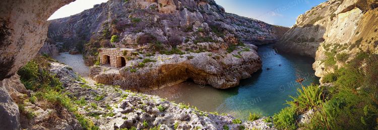
From the Village Square, a road leads to the fabulous valley of Wied il-Għasri. On the way, there are a number of typical farmhouses, most of them available for short or long lets, as well as an old charming chapel dedicated to the Patronage of the Blessed Virgin Mary. The Wied il-Għasri area is a marvellous country walk or cycling site especially in Winter and Spring. The valley ends in the sea, wedged between high cliffs where a secluded little inlet makes it ideal for swimming, snorkelling and diving. Indeed, the sea around Wied il-Għasri is very popular among divers. In Għasri valley one can find some saltpans.
The village church, designed by a local priest, Dun Ġużepp Diacono, was built early in the twentieth century. Its foundation stone was laid on 6 September 1903 and it was dedicated to the Corpus Christi, otherwise known as Christ the Saviour in the Eucharist on 9 January 1916. The village was established a parish by Bishop Giovanni Maria Camilleri on 16 December 1921.