
 | ||
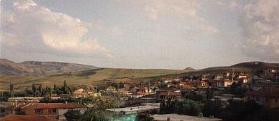
Gümerdiğin is the larger of the two towns of Şabanözü. Gümerdiğin is nearly 6 km northwest of Şabanözü and nearly 80 km from Ankara. Although Şabanözü is a district of Çankırı, Gümerdiğin is mostly in relation with Ankara.
Contents
- Map of GC3BCmerdiC49Fin GC3BCmerdiC49Fin Mahallesi 18650 C59EabanC3B6zC3BC2FC387ankC4B1rC4B1 Turkey
- Economy
- Education
- History
- Health
- Demographics
- References
Map of G%C3%BCmerdi%C4%9Fin, G%C3%BCmerdi%C4%9Fin Mahallesi, 18650 %C5%9Eaban%C3%B6z%C3%BC%2F%C3%87ank%C4%B1r%C4%B1, Turkey
Economy
Agriculture is the main part of the economy. There are two artificial lakes and also Sanı Çayı ise used to supply water for the fields. Wheat, beans, apple and a brunch of vegetables are the main produce.
Education
In Gümerdiğin there's a primary and a middle school but not a high school. The students from some neighbouring villages also attend school here.
History
The town was named after Seljuk commander Humar Tigin who came to the area after the Battle of Manzikert with his clan. The name was slowly corrupted over time to its present form Gümerdiğin.
Health
In Gümerdiğin there's a state health office. In the office there a nurse, and a health officer but no doctor. When a doctor is needed people are transferred to Şabanözü where there's a State Hospital. Gümerdiğin is also lack of Pharmacy and the medicals can be obtained from Şabanözü also.
Demographics
Gümerdiğin's population is as follows;