Time zone EET (UTC+2) Licence plate 06 Area 1,010 km² Area code 0312 | Region Central Anatolia Postal code 06xxx Elevation 970 m Local time Monday 12:31 AM | |
 | ||
Weather 5°C, Wind NE at 8 km/h, 90% Humidity University Turkish National Police Academy | ||
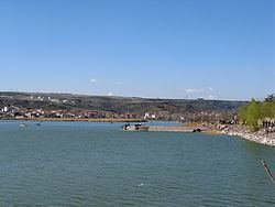
Gölbaşı is a town and district of the Ankara Province in the Central Anatolia region of Turkey, 20 km (12 mi) south of the city of Ankara. According to a 2010 census, the population of the district is 95,109, 93,852 of whom live in the town of Gölbaşı. The district covers an area of 738 km2 (285 sq mi), and the average elevation is 970 m (3,182 ft). The district includes the Mogan and Eymir lakes.
Contents
Map of G%C3%B6lba%C5%9F%C4%B1, 06830 G%C3%B6lba%C5%9F%C4%B1%2FAnkara, Turkey
Although the lakes are polluted and infested with mosquitoes, the picnic areas and lakeside restaurants of Gölbaşı serve as a popular retreat from the city for the people of Ankara. A number of government departments have accommodations here, and the town is slowly but surely joining up with the city as the green space between the two disappears. Türk Telekom have their satellite ground control in the area.
History
Archaeological research in the area has revealed occupation since 3000 BC by a succession of civilısations including Early Bronze Age, Hittites, Phrygians, Romans, and Byzantines. Excavated sites include Selametli, Tuluntaş, Tuluntaş-Ortaçayır, Kızılcaşar-Gökçepınar, Karagedik, Bacılar, Bezirhane Kültepe, Bezirhane-Kepenekçi and İncek-Harmantepe.
The area has long been occupied by Turks, and it was here that Timur hid his elephants in the woods before the Battle of Ankara.
