
- average 14 m/s (494 cu ft/s) Discharge 14 m³/s Mouth Mälaren | Length 80 km Basin area 1,982 km² | |
 | ||
Similar | ||
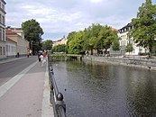
Uppsala city along fyris n sweden
Fyrisån ([ˈfyːrɪsˌoːn], the Fyris river) is a river in the Swedish province of Uppland, which passes through the city of Uppsala and ends in Lake Mälaren.
Contents
Map of Fyris, Sweden
In Old Norse, the river was called Fýri, and in later times it was known as the Full or the Sala river – Sala referred to the halls (Up-Salir) of the Swedish kings at Gamla Uppsala – but its name was changed in the 17th century in memory of the Fyrisvellir, marshy plains which had long since been turned to agriculture, but were famous from Norse mythology and as the site of the Battle of Fýrisvellir in the late 10th century.
Boats can sail up the river from Lake Mälaren all the way to central Uppsala where two weirs make further progress impossible. In the summer of 2007 the construction of a fish ladder was started, in order to make it possible for the asp, an endangered and potamodromous fish, to pass the weirs and reach its spawning waters. On the last day of April every year, students attempt to navigate the weirs on homemade rafts with predictable results.