Archipelago Babuyan Islands Highest elevation 191 m (627 ft) Region Cagayan Valley Max length 35.4 km Province Cagayan Adjacent body of water Luzon Strait | Adjacent bodies of water Babuyan Channel Highest point Mount Nanguringan Elevation 191 m Island group Babuyan Islands Municipality Aparri | |
 | ||
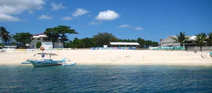
Fuga Moro Island is an island in the municipality of Aparri, Cagayan. With an area of 100 square kilometres (39 sq mi), it constitutes one of 42 barangays of Aparri along with the neighbouring islets of Barit (4.8 square kilometres (1.9 sq mi)) and Mabag (0.7 square kilometres (0.27 sq mi)).
Contents
Map of Fuga Island, Aparri, Philippines
Though under the jurisdiction of mainland Aparri, it is part of the Babuyan Archipelago, the second-northernmost island group of the Philippines. The highest peak is Mount Nanguringan in the northeast, with an elevation of 191 metres (627 ft).
According to the 2000 population census, it has 1,786 people in 312 households. The principal settlement is Naguilian (Musa) village on the southern coast.
The island still retains a traditional culture, a manifestation of which is the annual construction of a small straw imitation boat that is floated out to sea. The tradition began in 1656 when the island was almost invaded by British ships, prompting islanders to make a similar replica of a boat, thus preventing the island's annexation by Great Britain.
Presently, Fuga Island is owned by Fuga Island Holdings. It was formerly owned by the Dominican Order under the encomienda system during the Spanish period eventually returned to the Filipinos after the signing of The Treaty of Paris. Former owners were Sycip Family, Alfonso Lim, Tan Yu and now Fuga Island Holdings of the Serafica Family. The first land title was issued in 1908 under Original Certificate Title number two (2). The government of the Philippines, in recognition of the development of this private land declared by national legislation that Fuga Island and its surrounding mainland port facilities be designated an economic zone as part of the Cagayan Special Economic Zone (CEZA) and Freeport under Republic Act No. 7922.
Archaeology
From January 31, 1978 to February 22, 1978, Bryan E. Snow and Richard Shutler, Jr. conducting an archaeological excavation on Fuga Moro Island. Only earthenware, pottery, porcelains, and stoneware were found during the excavation. Problems also occurred during the excavation, ranging from signs of recent disturbances to sites being insufficient organic material quantity for dating processes.
Geology
The island's stratigraphy is composed of a 20-metre (66 ft) thick layer of volcanic breccia on top of a layer of volcanic rock fragments and feldspar. The lower layer has a 10-centimeter-thick baked zone present on top of it. The weathering of the volcanic breccia has caused the upper 2 metres (6 ft 7 in) of this layer to form red-brown clay-rich soil. Land-forms such as cliffs and wave-cut platforms can be seen all around the island due to the hardened volcanic breccia. Separated from the beach ridge by coconut palms, a grassy area is found in the interior of the island.
There were two archaeological sites that were tested. Designated as Site 1 (78-MI-1) and Site 2 (78-MI-2). Site 1 was in a backshore area leading to sea cliffs. It is located in a topographically low area which allowed it to be deposited by sediments from nearby slopes. Site 2 is located at a beach ridge, specifically its crest, 18 meters inland from the shore-face.
Surveying and fieldwork
Initial surveying was conducted around Palaui Island, a larger northerly island and around San Vicente on mainland Luzon. Both areas were designated with 3 and 2 sites respectively.
Site 1 consisted of ten 2mx2m square units with each square subdivided into four 1mx1m sub-units, each sub-unit labeled according to cardinal directions. Square 2NW (2 - North West) and 4NW were excavated to 10 cm and 20 cm depth. Recovered from these squares where two dozen red chert flakes, and two stoneware sherds. The subsurface was found to be completely sterile and excavation was stopped.
Site 2 was in the land owned by an elderly man and his wife. Ceramic shards were scattered over and area of around 0.5 acre. Three test trenches were laid named TT-1, TT-2, & TT-3, all containing squares with size 1mx1m. Test Trench 1 contained seven squares labelled as 1SW-7SW. Excavation was halted after a depth of 100 centimetres (39 in) below surface due to area being sterile in any cultural materials. Test Trench 2 consisted of eight squares labelled 1-8. Test Trench 3 consisted of four squares labelled 1–4. All were excavated to a depth of 110 centimetres (43 in).
Site disturbances were cause by three main factors according to the excavators.
- Bioturbation caused by crab burrowing
- Surface disturbance due to present residences
- Past surface disturbance as seen in strata in different units in TT-2 being unaligned.
The overall excavation recovered 1036 artifacts. The bulk of these recoveries were earthenware sherds, porcelain, and stoneware. Faunal remains were also found in TT-1 and TT-3. None were found in TT-2. Also in TT-1, 2 turtle carapaces were recovered and 9 small unanalyzable bone fragments. Dating on the carapaces were unsuccessful due to its water-worn and fragile state. Collagen samples could not be extracted from them. Twenty bone fragments were found in TT-3. Only two bones were classified as a pig tooth and a deer metapodial fragment. The remaining bones were classified as being part of a medium-sized mammal. Also in TT-3, 72 shell fragments were also found.
