
Admin. region Kassel Elevation 388 m (1,273 ft) Local time Friday 6:21 PM | Time zone CET/CEST (UTC+1/+2) Population 2,429 (30 Jun 2009) | |
 | ||
Weather 8°C, Wind W at 18 km/h, 57% Humidity Points of interest Wasserburg Friedewald, Dreienberg, Burgruine Dreienburg | ||
Friedewald is a community in Hersfeld-Rotenburg district in eastern Hesse, Germany, directly east of Bad Hersfeld.
Contents
- Map of Friedewald Germany
- Location
- Neighbouring communities
- Constituent communities
- History
- Community council
- Mayor
- Coat of arms
- Transport
- Established businesses
- Museums
- Buildings
- Sons and daughters of the town
- References
Map of Friedewald, Germany
Location
The community lies in the boundary zone between the Kuppenrhön and the Seulingswald ranges. Friedewald lies on the watershed between the Fulda and the Werra, and at the foot of the Dreienberg, which is among the northernmost outliers of the Rhön.
Neighbouring communities
Friedewald borders in the north on the communities of Ronshausen and Wildeck, in the east on the town of Heringen and the community of Philippsthal, in the southeast on the community of Hohenroda, in the south on the community of Schenklengsfeld and in the west on the town of Bad Hersfeld and the community of Ludwigsau (all in Hersfeld-Rotenburg).
Constituent communities
Friedewald’s Ortsteile, besides the main centre, also called Friedewald, are Lautenhausen, Hillartshausen and Motzfeld.
History
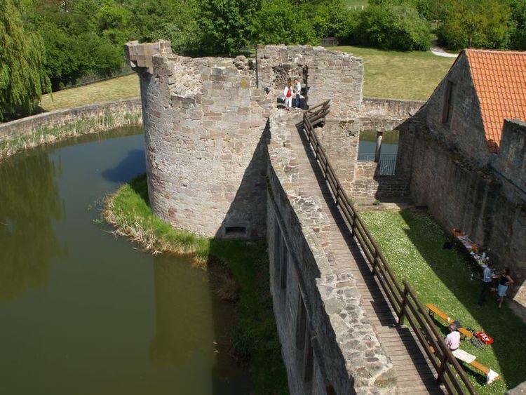
The Amt of Friedewald (with market rights and jurisdiction) had its first documentary mention in 1392, as did the community itself in 1430. An abbot’s castle stood here as early as 1312, which as a fief of the Hersfeld Abbey was given over to the Landgraves of Hesse. The castle is believed to have been built to watch over the trade road called Kurze Hessen, which ran from Frankfurt to Leipzig.
In 1472, this castle was torn down and Landgrave Heinrich III had a moated castle built here by his building master Hans Jakob von Ettlingen, which served the Landgraves during their hunting stays. Friedewald Castle with its four corner towers was destroyed in 1762. On 5 October 1551, the treaty between France and the Princes of Schmalkalden that provided for Landgrave Philipp I’s freedom from his Imperial imprisonment was signed here. The castle is still the community’s middle point and landmark.
Community council
The municipal election held on 26 March 2006 yielded the following results:
The community’s executive (Gemeindevorstand) is made up of five members, with one seat allotted to the SPD, two to the CDU and 1 each to the Bürgerliste-pro-Friedewald and the independent mayor.
Mayor
The mayor Martin Gröll (independent) was elected on 2 February 2003 with 83.6% of the vote.
Coat of arms
The community’s arms might be described thus: Gules a wall and tower embattled argent therein a three-tiered fountain sable, the chief four oakleaves each with an acorn argent.
The German blazon refers to the wall and tower as a “castle silhouette with crenellations”.
Transport
The community lies on Autobahn A 4 (Aachen–Görlitz), interchange 33. Furthermore, Bundesstraße 62 runs through the community from Bad Hersfeld to Bad Salzungen.
Established businesses
In early 2009, Hermes Logistik Gruppe will bring its newest main goods handling base into service, with an area of 100 000 m² and a building with 18 000 m².
Moreover, Schenker Deutschland AG runs one of Europe’s most efficient such facilities, which for Schenker is of central importance, especially for general cargo shipped within Germany.