
OS grid reference TQ129455 Local time Friday 4:55 PM | Sovereign state United Kingdom Postcode district RH5 Dialling code 01306 | |
 | ||
Weather 9°C, Wind SW at 23 km/h, 64% Humidity | ||
Paul weller live friday street
Friday Street is a hamlet (rural neighbourhood) on the gentle lower north slope of Leith Hill in Surrey, England. It is in a wooded headwater ravine, just to the south of Wotton and the A25, a single rather than dual road, running between Guildford to the west and Dorking to the east.
Contents
- Paul weller live friday street
- Map of Friday Street Dorking UK
- Paul weller friday street
- History and geography
- Landmarks
- Former landmarks
- In film fiction and the media
- References
Map of Friday Street, Dorking, UK
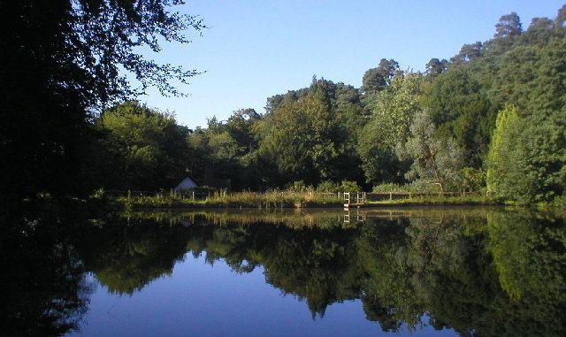
Statistically it is insufficient to make up a census unit. Friday Street also has varied map definitions and is part of the relatively sparsely populated civil parish of Wotton (where the 2011 Census population was included). Its lake is one of three hammer ponds in the Vale of Holmesdale in Surrey. These were used from the medieval age until the early 19th century when wholly surpassed by metalwork production specialist centres, principally Sheffield and the West Midlands (region), assisted by cheap inter-regional transport, coal replacing charcoal as a fuel and by technological advances, being in a narrow band of ironstone-rich hills, the Greensand Ridge. Central to Friday Street on most maps is its hammer pond.
Paul weller friday street
History and geography
Fewer than 20 houses have been built and the area is surrounded by the second largest wooded common in Surrey, Wotton Common also known as Leith Hill Common, preceded by the Hurtmoor in the same range of hills, the Greensand Ridge.
Under censuses conducted by the Office for National Statistics Friday Street is too small to make up a census unit centred on it, or without including other land and has varied map definitions.
Landmarks
The largest home is on debatable borders of the hamlet, Wotton House. The next largest home Pond Cottage was built according to English Heritage "possibly for an iron master". It is timber framed 17th century and clad in galleted Bargate rubble to the lower storey with bricks above and its wall plate exposed under a tiled roof.
Former landmarks
A former inn bore the name of Stephan Langton, Archbishop of Canterbury during the reign of King John and signatory of the Magna Carta and Martin Tupper, poet and antiquarian, wrote a biography of Stephan Langton in 1858 depicting his time in this area.
In film, fiction and the media
Friday Street also features as the title of a song on the album Heavy Soul by Surrey native Paul Weller.
In 1984 Friday Street was used as a location for the BBC Television series "The Tripods" based on the books by John Christopher, where, for the sake of the story it became the fictional future village of "Wherton."