
Mountain type main dolomite Elevation 2,332 m | Normal route Freiungen Ridgeway | |
 | ||
Prominence 2,332-2,104 m ↓ Eppzirler Scharte First ascent 1886/1890 by August and Fraja Lieber (tourists) Similar Reither Spitze, Erlspitze, Kuhljochspitze, Großer Solstein, Kleiner Solstein | ||
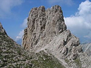
The Freiungspitzen (plural) are a group of 3 peaks in the Erlspitze Group in the Karwendel Alps on the territory of the Austrian municipality of Zirl. The highest summit, the west top, has a height of 2,332 m (AA), the middle top is 2,322 m (AA) and the east top is 2,302 m (AA).
Contents
Map of Freiungspitzen, 6170 Zirl, Austria
Ascents
The Freiungen Ridgeway (Freiungen-Höhenweg, a partially secured mountain path) between the Nördlinger Hut and the Solsteinhaus runs past the tops. The west top of the Freiungen is easy to ascend.
Literature
References
Freiungspitzen Wikipedia(Text) CC BY-SA