
Population 268 (2011 census) Postal code 4309 | Postcode(s) 4309 Frazerview KalbarFassifern | |
 | ||
Frazerview is a locality in the Scenic Rim Region of Queensland, Australia. Frazerview is located in the Fassifern Valley farming area to the west of Cunningham Highway. At the 2011 Australia Census the locality and surrounds recorded a population of 268. Part of the south-eastern boundary of Frazerview is marked by Warrill Creek, a tributary of the Bremer River.
Map of Frazerview QLD 4309, Australia
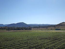
Mount Fraser rises in the west of Frazerview. Its slopes have remained vegetated. Kangaroo Mountain occupies central areas while the eastern parts feature irrigated farms close to Warrill Creek.
Frazerview State School was opened on 25 November 1915. Three days later the school was destroyed by fire. It was re-opened one year later and continued to education children until December 1975 when the school was closed due to low attendance rates.