
Area rank 251 in Norway Area 369.6 km² Population 9,614 (2013) | Demonym(s) Frening Local time Saturday 4:35 AM | |
 | ||
Weather -1°C, Wind NW at 8 km/h, 90% Humidity Points of interest Ergan Coastal Fort, Eventyrlige Skaret ‑ Skarstua, Jendemsfjellet | ||
Fræna is a municipality in Møre og Romsdal county, Norway. It is part of the region of Romsdal. The municipality is located on the Romsdal peninsula surrounding the Frænfjorden, the eastern shore of the Julsundet strait, and includes most of the Hustadvika area. It also includes the now-abandoned Bjørnsund islands.
Contents
Map of Fr%C3%A6na Municipality, Norway
The main village and administrative centre in Fræna is Elnesvågen with over 2,300 inhabitants. Moxy Engineering, Hustad Marmor, and Tine Meierier are all factories located in Elnesvågen. Other villages in Fræna include Hustad, Bud, Tornes, Sylte, Malme, and Aureosen. The area is nice for hiking, including the mountains are Heiane/Lågheiane and Jendemsfjellet.
General information
The municipality of Fræna was established in 1840 when it was separated from the municipality of Akerø. The original municipality was named Vaagø and it surrounded the Frænfjorden. Later the name was changed to Fræna.
On 1 January 1964, Bud Municipality and Hustad Municipality were merged with Fræna to form a new, larger municipality of Fræna.
Name
The municipality is named after the Frænfjorden (Old Norse: Fræni). The meaning of the name is unknown, but it might be derived from frænn which means "bright" or "shiny". Before 1865, the parish and municipality were named Vaagø (and the main church was Vågøy Church, which also was historically spelled Vaagø). From 1865-1918, the name was written Frænen, and since 1918 it has had its current spelling, Fræna.
Coat-of-arms
The coat-of-arms is from modern times. They were granted on 15 May 1995. The arms show three blue waves on a gold background. The arms were chosen to symbolize the municipality's connection to the sea.
Churches
The Church of Norway has four parishes (sokn) within the municipality of Fræna. It is part of the Molde arch-deanery in the Diocese of Møre.
Geography
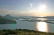
The municipality of Fræna sits on the northwestern end of the Romsdal Peninsula. The Norwegian Sea lies to the north, the Harøyfjorden, Julsundet strait, and Aukra Municipality lie to the west, Molde Municipality lies to the south, and Gjemnes Municipality and Eide Municipality lie to the east.
The Frænfjorden cuts into the middle of the municipality. The coastal areas are low and marshy while the interior of the municipality is mountainous. Two of the more notable mountains are Jendemsfjellet and Heiane. The Bjørnsund islands lie off the northwestern coast of Fræna. They are now uninhabited, but the Bjørnsund Lighthouse is still in operation.