
- left Scotia Brook Basin area 29 km² | Country United Kingdom | |
 | ||
Fowlea Brook flows through Staffordshire and the outlying areas of Stoke-on-Trent, England. It is a tributary stream of the River Trent, and is 6 miles (9.7 km) long.
Contents
Map of Fowlea Brook, Stoke-on-Trent, UK
Course and catchment
Its source is on the high ground near Peacock Hay. The brook flows south-east in a narrow valley, past Chatterley where it is partially culverted near the Chemical Lane industrial estate. It reappears as it passes Westport Lake, but is culverted again beneath Longport, where it is joined by its only named tributary the Scotia brook.
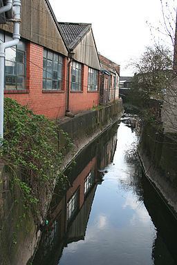
It then flows through the Eturia valley alongside the Festival Park site, and Cliffe Vale, before passing through the city centre of Stoke-on-Trent, where it also culverted. The brook then flows to the east, joining the Trent between Stoke and Fenton, beneath the dual carriageway of the A500. The brook has been designated as main river between Middleport and the confluence with the Trent.
The catchment or drainage basin lies between that of the Ford Green Brook to the north and east, and that of the Lyme brook to the south and west, has an area of 29 square kilometres (11 sq mi).
Pollution
During the industrial revolution the Fowlea valley was chosen as the location for the Wedgwood pottery factory, further growth took place with the arrival of the Trent & Mersey canal, with brick, tile and sanitary ware factories being built nearby. Heavy industry in the form of coal mines, and steel works also developed in the valley, culminating in the Shelton Bar steel works and rolling mill in the 1960s.
The discharges from these industrial processes and the effluent from sewage works meant that the brook and River Trent in the Potteries became heavily polluted. Effluent from Burslem, Hanley, Tunstall and Wolstanton all found its way into the brook. In Tunstall, prior to the opening of a sewage works in 1878, legal action had been threatened due to the continued pollution of the canal and the brook.
In the 1950s when the pollution was at its worst, the Trent River Board stated that "in the Stoke-on-Trent area, reaches of the Trent and the Fowlea brook were considered to be a potential danger to public health". The brook was then the most heavily polluted stream in the Potteries, and devoid of any fish.
The improvements that were subsequently made to the brook mean that it is classed as having moderate ecological quality under the Water Framework Directive. This is middle of the bands in the five part framework scale, which ranges from high, good, and moderate, through to poor and finally bad.
At Westport Lake, a local nature reserve, the brook is now considered a significant nature corridor where it runs through the wildlife site.