
Area 991.5 km² Surface elevation 686 m | Lake type Reservoir Max. length 134 mi (216 km) Length 215.7 km Mean depth 23 m | |
 | ||
Primary inflows Catchment area 57,500 sq mi (149,000 km) Fish Northern pike, Chinook salmon, Walleye, Smallmouth bass, Lake trout, Sauger | ||
Fort Peck Lake, or Lake Fort Peck, is a major reservoir in Montana, formed by the Fort Peck Dam on the Missouri River. The lake lies in the eastern prairie region of Montana approximately 140 miles (230 km) east of Great Falls and 120 miles (190 km) north of Billings, reaching into portions of six counties.
Map of Fort Peck Lake, Montana, USA
The dam and reservoir were built in the 1930s to enhance navigation on the Missouri River, and supply enough water to provide a 9-foot deep channel from Sioux City, Iowa, to the mouth of the Missouri just above St. Louis. Following severe flooding along the Missouri River in 1943, which hampered the economic development of the Missouri River Valley and damaged production of military supplies for then-ongoing World War II, five additional dams were added when the federal government adopted the Pick-Sloan Plan, calling for a series of dams and reservoirs to be built along the Missouri and its tributaries. Fort Peck Dam was built from 1933 to 1940 by the U.S. Army Corps of Engineers; water impoundment began in 1937 and the reservoir was first filled to capacity in 1947.
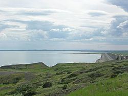
With a volume of 18,700,000 acre feet (23.1 km3) when full, Fort Peck is the fifth largest artificial lake in the United States. It extends 134 miles (216 km) through central Montana, and its twisting, inlet-studded shoreline has a total length of some 1,520 miles (2,450 km). Along with the Missouri River, smaller tributaries such as the Musselshell River, Fourchette Creek, Timber Creek, Hell Creek and Dry Creek feed the reservoir; the latter forms the longest side arm of the reservoir, which reaches some 30 miles (48 km) southwards. The lake covers an area of 245,000 acres (99,000 ha), making it the largest in Montana by surface area, although Flathead Lake has a larger volume due to its greater depth.
The reservoir is also a tourist attraction, with 27 designated recreational sites bordering its shores. Bordering nearly the entire reservoir is the 1,719-square-mile (4,450 km2) Charles M. Russell National Wildlife Refuge, which has preserved much of the high prairie and hill country around the lake in a more or less natural state.