
Controlled by United States | ||
 | ||
Garrison 60th Air Defense Artillery Regiment | ||
Fort Frank (Carabao Island, the Philippines) was one of the defense forts at the entrance to Manila Bay established by the United States. The entire island was designated as Fort Frank, in honor of Brigadier General Royal T. Frank, as part of the harbor defenses of Manila and Subic Bays built by the Philippine Department of the US Army in the early 1900s.
Contents
Map of Carabao Island, Philippines
Geography
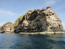
Carabao Island is located near the southern end of the entrance to Manila Bay about 0.5 miles (0.80 km) off the coast of Maragondon in the province of Cavite. The long, narrow island is surrounded by sheer cliffs over 100 feet (30 m). The whole island and fort has an area of 44.5 acres (18.0 ha) with the highest elevation at 185 feet (56 m).
History
The establishment of the Islands of Manila bay as military reservations was requested by Army President Theodore Roosevelt and enacted by Executive Order on April 11, 1902.
On February 21, 1942, thirty four soldiers were killed by Japanese Artillery when a round ricocheted into a tunnel at Fort Frank.