
Established Late 18th century City status 12 November 1959 Elevation 1,000 m Local time Wednesday 2:23 AM | Municipality Fortín Town status 15 July 1955 Time zone CST (UTC-6) Population 18,965 (2005) | |
 | ||
Weather 15°C, Wind NW at 5 km/h, 81% Humidity | ||
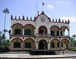
Fortín de las Flores is a city in the Mexican state of Veracruz. Fortín de las Flores is the municipal seat of Fortín municipality, which borders the municipalities of Córdoba, Naranjal and Ixtaczoquitlán. It stands on Federal Highways 190 and 180 and the Mexico City to Veracruz railway.
Map of Fort%C3%ADn de las Flores, Ver., Mexico
In the 2005 INEGI Census, the city reported a total population of 18,965, with 53,311 in the surrounding municipality.
The ravine of Metlac, which borders the Cañón del Río Blanco National Park, is the most famous feature of Fortín de las Flores.
The residents of Fortín de las Flores are considered by freighthopping Central American migrants to be some of the most generous in Mexico.
References
Fortín de las Flores Wikipedia(Text) CC BY-SA