
- land 1.4 sq mi (4 km) - summer (DST) EDT (UTC-4) | - water 0.0 sq mi (0 km), 0% Population 4,669 (2000) | |
 | ||
Apparition from a church in flourtown pennsylvania
Flourtown is a census-designated place (CDP) in Springfield Township, Montgomery County, Pennsylvania, United States, with a ZIP code of 19031. Flourtown is adjacent to the neighborhoods of Erdenheim, Oreland, Whitemarsh, and Chestnut Hill. The population of Flourtown was 4,538 at the 2010 census.
Contents
- Apparition from a church in flourtown pennsylvania
- Map of Flourtown PA USA
- History
- Geography
- Demographics
- Organizations
- Educational institutions
- Notable people
- References
Map of Flourtown, PA, USA
History
The community was so named on account of a flouring mill near the original town site.
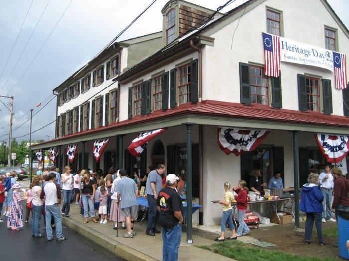
The Black Horse Inn was listed on the National Register of Historic Places in 2005.
Geography
Flourtown is located at 40°6′19″N 75°12′27″W (40.105377, -75.207524).
According to the United States Census Bureau, the CDP has a total area of 1.4 square miles (3.6 km2), all of it land.
Demographics
As of the 2010 census, the CDP was 89.3% White, 5.3% Black or African American, 0.1% Native American, 2.1% Asian, 0.4% were Some Other Race, and 1.5% were two or more races. 1.8% of the population were of Hispanic or Latino ancestry.
As of the census of 2000, there were 4,669 people, 1,746 households, and 1,292 families residing in the CDP. The population density was 3,305.0 people per square mile (1,278.5/km2). There were 1,772 housing units at an average density of 1,254.3/sq mi (485.2/km2). The racial makeup of the CDP was 93.72% White, 3.30% African American, 1.84% Asian, 0.32% from other races, and 0.81% from two or more races. Hispanic or Latino of any race were 0.69% of the population. 24.2% were of Irish, 14.2% Italian, 12.7% German and 11.5% English ancestry according to Census 2000.
There were 1,746 households, out of which 32.1% had children under the age of 18 living with them, 64.0% were married couples living together, 7.4% had a female householder with no husband present, and 26.0% were non-families. 22.2% of all households were made up of individuals, and 12.5% had someone living alone who was 65 years of age or older. The average household size was 2.58 and the average family size was 3.05.
In the CDP, the population was spread out, with 23.5% under the age of 18, 4.3% from 18 to 24, 25.5% from 25 to 44, 26.0% from 45 to 64, and 20.7% who were 65 years of age or older. The median age was 43 years. For every 100 females there were 88.8 males. For every 100 females age 18 and over, there were 82.3 males.
The median income for a household in the CDP was $76,465, and the median income for a family was $88,249. Males had a median income of $59,844 versus $42,472 for females. The per capita income for the CDP was $32,848. About 1.0% of families and 1.8% of the population were below the poverty line, including 1.0% of those under age 18 and 2.2% of those age 65 or over.
Organizations
Flourtown Fire Company was established in 1910 and provides fire/emergency services to Springfield Township and the communities of Flourtown, Erdenheim, Oreland, Wyndmoor and beyond through mutual aid agreements.
The Klingon Language Institute was founded here in 1992.