
Country Germany Admin. region Oberpfalz Elevation 644 m (2,113 ft) Area 23.26 km² Local time Monday 4:51 PM Administrative region Upper Palatinate | State Bavaria District Neustadt a.d.Waldnaab Time zone CET/CEST (UTC+1/+2) Population 1,699 (31 Dec 2008) Postal code 92696 | |
 | ||
Weather 7°C, Wind W at 8 km/h, 45% Humidity | ||
Flossenbürg (Northern Bavarian: Flossenbirch) is a municipality in the district of Neustadt an der Waldnaab in Bavaria in Germany. The state-approved leisure area is located in the Bavarian Forest and borders the Czech Republic in the east. During World War II, the Flossenbürg concentration camp was located here.
Contents
Map of 92696 Flossenb%C3%BCrg, Germany
History
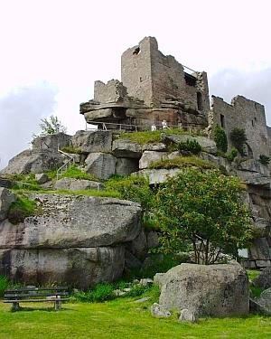
The first reference of Flossenbürg’s existence was in 948. Its castle was the Hohenstaufen's stronghold. Later, Flossenbürg belonged to the duchy of Neuburg-Sulzbach and came to the country court of Floß in the electorate of Bavaria in 1777. Today, it is located in the administrative region of Oberpfalz.
The town was the site of Flossenbürg concentration camp from 1938 until 1945. On April 23, 1945, the U.S. 90th Infantry Division of the 3rd Army liberated the camp and took it without any fighting.
Transport
Flossenbürg was the terminus of the Floß–Flossenbürg railway line that branched off in Floß from the Neustadt (Waldnaab)–Eslarn railway and is served today by a bus route from Weiden via Neustadt an der Waldnaab to the Silberhütte Cross-Country Skiing Centre.