
 | ||
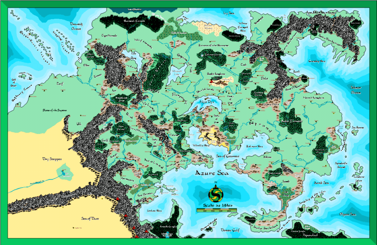
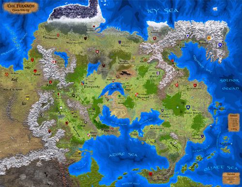
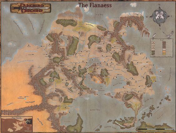
The Flanaess is the eastern part of the continent of Oerik, one of the four continents of the fictional world of Oerth in the World of Greyhawk campaign setting for the Dungeons & Dragons fantasy roleplaying game. The Flanaess has been the setting of dozens of adventures published between the 1970s and 2000s and continues to be the central focus of the campaign world.
Contents
- Development of the Flanaess
- Races
- Geography
- Aerdy
- Ahlissa
- Almor
- Amedio Jungle
- Baklunish Basin
- Bandit Kingdoms
- Bissel
- Blackmoor
- Bone March
- Bright Lands
- Celene
- County of Ulek
- Empire of Iuz
- Administrative divisions
- Ferrond
- Frost Barbarians
- Furyondy
- Keoland
- Ket
- 1980 World of Greyhawk folio edition
- Sea of Death Gygax Delineates His Vision of Ket 1987
- The Greyhawk Wars Ket takes center stage 1990
- Wizards of The Coast updates the Greyhawk campaign 1998
- Living Greyhawk Campaign 20012008
- Land of Black Ice
- Nyrond
- Nyrond in the Living Greyhawk campaign
- Pale
- Plains of the Paynims
- Rovers of the Barrens
- Scarlet Brotherhood
- Sheldomar Valley
- Sterich
- Sulm
- Tenh
- Thillonrian Peninsula
- Ull
- Verbobonc
- Wild Coast
- Yeomanry
- Calendar
- Weather
- References
Development of the Flanaess
In late 1972, Dave Arneson demonstrated a new type of game to a group of gamers in Lake Geneva, Wisconsin, including game designer Gary Gygax. Gygax agreed to develop a set of rules with Arneson and get the game published; the game eventually became known as "Dungeons & Dragons". Gygax designed a set of dungeons underneath the ruins of Castle Greyhawk as a testing ground for new rules, character classes and spells. In those early days, there was no "Flanaess"; the world map of "Oerth" was developed by Gygax as circumstances dictated, the new cities and lands simply drawn over a map of North America. Gygax and his friend Rob Kuntz further developed this campaign setting, and by 1976, the lands within a radius of 50 miles had been mapped in depth, and the lands within a radius of approximately 500 miles were in outline form. In addition, more distant lands had been roughly sketched out to accommodate various adventures. (For more information about the first days of Gygax's home campaign, see Greyhawk.)
Following yet more work, in 1978 Gygax agreed to publish his world and decided to redevelop Oerth from scratch. Once he had sketched out the entire planet to his satisfaction, one hemisphere of Oerth was dominated by a massive continent called Oerik. Gygax decided to concentrate his first efforts on the continent of Oerik and asked TSR's printing house about the maximum size of paper they could handle; the answer was 34" x 22" (86 cm x 56 cm). He found that, using the scale he desired, he could fit only the northeast corner of Oerik on two of the sheets. This corner of Oerik became known as "the Flanaess", so named in Gygax's mind because of the peaceful people known as the Flannae who had once lived there. Gygax also added many more new regions, countries and cities, bringing the number of political states to 60:
Needing original placenames for all of the geographical and political places on his map, Gygax sometimes resorted to wordplay based on the names of friends and acquaintances. For instance, Perrenland was named after Jeff Perren, who co-wrote the rules for Chainmail with Gygax; Urnst was a homophone of Ernst (his son Ernie); and Sunndi was a near-homophone of Cindy, another of Gygax's children.
From Gygax's prototype map, Darlene Pekul, a freelance artist in Lake Geneva, developed a full colour map on a hex grid. Gygax was so pleased with the end result that he quickly switched his home Greyhawk campaign over to the new world he had created.
This map formed the basis of the World of Greyhawk when it was published as the 32-page The World of Greyhawk folio in 1980.
Gygax also developed a thousand-year history for the Flanaess that involved a series of cultural and military invasions: the peaceful Flannae had been pushed out by the warlike Suloise; the Suloise in turn had been pushed out by the noble Oeridians, who set up a Great Kingdom of peace and prosperity. However, by 576 CY (the year Gygax chose for his setting), the Oeridian empire had grown decadent and evil, and many subservient regions were rising up in rebellion.
In 1992, after Gygax had been forced out of TSR, the storyline of the Flanaess was moved forward a decade by the From the Ashes boxed set, which dealt with the aftermath of wide-ranging conflict known as The Greyhawk Wars. In 1998, the storyline was advanced even further, to 591 CY, by The Adventure Begins softcover. The massive multiplayer Living Greyhawk campaign, which started in 2001, used The Adventure Begins as a starting point, and advanced the timeline of the campaign ahead one year for each of real-world time. For example, in 2002, the campaign year was 592 CY. In 2003, it was 593 CY.)
Races
As well as being home to a number of demihuman and humanoid races, it is also inhabited by the Suel, Bakluni, Oerid, and Flan subraces of humanity.
Geography
The Flanaess can be broken down geographically as follows: the Baklunish Basin in the northwest, the Empire of Iuz in the north, the Thillonrian Peninsula in the northeast, the Sea of Dust in the far west, the Sheldomar Valley in the west, old Ferrond and its southern frontier (including the City of Greyhawk) at the center of the Flanaess, old Sulm and the Aerdy frontier to the east, the old Great Kingdom to the far east, and the Amedio Jungle to the southwest.
Aerdy
Aerdy properly refers to the now-defunct Kingdom of Aerdy. Sometimes "Aerdy" is used in reference to the Oeridian tribe which founded the kingdom, though the proper term for the tribe is "Aerdi" (/ˈɛərdi/ AIR-dee) (which is also the adjectival form). "Aerdy" can also be used in reference to the Great Kingdom of Aerdy, the imperial successor state of the Kingdom of Aerdy.
Ahlissa
The ancient Flan kingdom of Ahlissa was founded over 1,700 years ago by the legendary Queen Ehlissa the Enchanter. Modern Ahlissa is generally located in the southeastern portion of the Flanaess, and is one of the largest countries on the subcontinent. Ahlissa is a feudal empire with hereditary rulership, and is currently ruled by His Transcendent Imperial Majesty, Overking Xavener I, Grand Prince of Kalstrand, Crowned Head of House Darmen.
Almor
In 586 CY King Lynwerd I of Nyrond seized the western half of Almor (/ˈælmɔːr/ AL-mawr), placing it under his protection and creating the Almorian Protectorate, and appointing a governor to administer the new province.
Amedio Jungle
The Amedio Jungle is a large stretch of tropical rainforest located in the southwestern Flanaess, on the continent of Oerik. Lying east of the Hellfurnaces, the Amedio extends over 300 leagues south from its northernmost point at Jeklea Bay. The border of the Amedio Jungle and the Hellfurnaces was the setting of Dungeon's Shackled City Adventure Path. This adventure detailed the history of the region between Jeklea Bay, the Amedio, and the Hellfurnaces, going back 3000 years to the time of the spellweavers' domination of the area. In that time, a battle between the Abyssal hordes and the forces of good took place around what is now the city of Cauldron.
Baklunish Basin
The Baklunish Basin is the northwestern portion of the Flanaess. Consisting chiefly of remnants of the ancient Baklunish Empire, the human peoples of these lands are known as the Baklunish. The most important parts of this region include the nations of Ekbir, Ket, Tusmit, Ull, and Zeif, as well as the Dry Steppes and the Plains of the Paynims. Though not technically part of the Baklunish Basin, the lands of the Tiger and Wolf Nomads are sometimes included, as they are populated by people of Baklunish stock.
The basin is bordered to the east by the Crystalmist Mountains, Yatil Mountains, and Barrier Peaks, and to the south by the Sulhaut Mountains. To the north, it is bordered by the Dramidj Ocean and to the west its limits are defined by the Tyurzi Mountains.
Bandit Kingdoms
The Bandit Kingdoms are generally located in the central portion of the Flanaess. They are governed by various petty dictatorships theoretically owing fealty to Iuz.
Bissel
Bissel, properly known as the March of Bissel, is a political state of the Flanaess.
Modern Bissel is generally located in the western-central portion of the Flanaess. It is bordered by the Barrier Peaks to the north and west, by the Dim Forest to the south, and by the Lorridges to the east.
As of 591 CY, the most populous towns are Thornward, and Pellak (pop. 2,300). Thornward itself was once the capital of Bissel, but is now a town governed jointly by Bissel, Gran March, Ket, and Veluna (resulting from an agreement known as the Thornward Division).
As of 591 CY, the population of Bissel totaled 123,880 persons, over 80% being humans of Oeridian, Suel, and Baklunish descent. Approximately 10% of the population is dwarven, with other humanoid races making up the remainder of the population.
The most popular deities among Bissel's citizens are Heironeous, Zilchus, Fharlanghn, Geshtai, Rao, and Istus.
The most widely spoken languages in Bissel include Common, various Baklunish dialects, and Dwarven.
Bissel is a feudal monarchy, and ruled by His Lofty Grace, Larrangin, the Margrave of Bissel, and owing fealty to Gran March and Veluna. The margrave is chosen by the leadership of the Knights of the Watch.
In the Living Greyhawk campaign, Bissel corresponded to New England (the states of Connecticut, Massachusetts, Rhode Island, Vermont, New Hampshire, and Maine).
The country itself is divided into twenty-six knight-baronies, eight townships, and one capital township, for the national capital of Pellak.
Bissel's coat of arms is blazoned thus: Per pale indented gules and argent, over all a tower sable.
Bissel is noted for producing foodstuffs, cloth, gold, and low-quality gems from mining operations.
Bissel's standard coinage is modeled after Keoland's, and consists of the platinum griffon (pp), gold lion (gp), electrum eagle (ep), silver stag (sp), and copper roc (cp).
Blackmoor
The original Blackmoor began life in the early 1970s as the personal setting of Dave Arneson, the co-creator of Dungeons & Dragons, first as a setting for Arneson's miniature wargames, then as an early testing ground for what would become D&D. Though published in booklet form by Tactical Studies Rules (TSR) in 1975, as the second supplement to D&D (the first being Greyhawk), Blackmoor actually predates Greyhawk as a campaign setting, a fact which Gary Gygax acknowledged in the foreword to the Blackmoor supplement.
Blackmoor as a location within the Greyhawk setting came about both as an inside-joke by Gygax, and as a way for him to acknowledge his fellow writers' creations (Len Lakofka's Lendore Isles occupy a similar position in the world). Having certain locations exist across the campaign settings of multiple DMs also became a convenient way to explain how player characters such as Mordenkainen (Gygax's character) and Robilar (Rob Kuntz's character) could be adventuring in Blackmoor's City of the Gods at one sitting, while exploring the dungeons of Castle Greyhawk the next.
Modern Blackmoor is generally located in the northwestern portion of the Flanaess. It is a small and inhospitable realm lying almost completely within the boundaries of the northern reaches of the Cold Marshes. The Burneal Forest forms a western boundary of sorts, while the Land of Black Ice does the same to the north.
As of 591 CY, the population of Blackmoor totaled 110,000 persons. Almost 40% of these inhabitants are humans of predominantly Flan and Oeridian stock, although some Suel and Baklunish can be found as well. Another 20% comprise orcish tribes that roam the region (some under the control of the Egg of Coot, some not). A slightly smaller percentage of halflings is also present, while elves, gnomes, half-orcs, half-elves, and other races make up the remainder of the population in increasingly smaller percentages.
As of 591 CY, the most populous town is Dantredun (pop. 700) on the edge of the Burneal. Blackmoor Town, the original capital of the archbarony, was conquered and destroyed in 541 CY by the "Egg of Coot", a mysterious being with a significant amount of magical power at his disposal. The "town" that serves as the Egg's home contains a number of automata (some reports place the number as high as 200), though very few living beings (if any) reside there
The actual structure of Blackmoor's government is unknown. His Luminous Preponderancy, Archbaron Bestmo of Blackmoor claims the title of "archbaron", and with it, rule over the ten underbaronies of the region. However, Teuod Fent, formerly of the Bandit Kingdoms, has claimed Ramshorn Castle as his own, and with it the title of "baron". Nonhuman tribes also roam the area, though their allegiances are usually only to themselves. The national capital is Dantredun (the seat of Bestmo's power).
Bone March
The Bone March is a political state of the Flanaess. The Bone March is generally located in the eastern portion of the Flanaess. It rests in the narrow strip of land bounded by the Rakers in the west and the Teesar Torrent in the east, and curving around to encompass Johnsport on the coast of the Solnor Ocean. The cool, rocky farmland of the Bone March is relatively poor and never supported a dense population or large cities. Its farmlands are now desolate wilderness.
As of 591 CY, the population of Bone March totaled 310,000 persons, though only a large minority are human (mainly Oeridian stock, but some Suel and Flan as well). About 20% of the population are orcs, and nearly the same number are halflings; gnomes, Elves, half-orcs, half-elves, and dwarves make up decreasing numbers of the remaining citizens.
As of 591 CY, the most populous towns are Knurl (13,500), Spinecastle (pop. 6,300(?)), and Johnsport (pop. 3,500(?)). The numbers above do not take into account the large number of other uncounted goblins, gnolls, etc.
The most popular deities among Bone March's inhabitants are Hextor, the Oeridian agricultural gods, Erythnul, Kord, the orc pantheon, and Beltar.
The most widely spoken languages in Bone March include Common, Old Oeridian, Orc, Halfling, Gnomish, and Elven. Goblin, Gnoll, and other nonhuman languages are spoken as well, due to the large numbers of those races present in the land.
Bone March was formerly a feudal marchland of the Great Kingdom, and ruled by His Nobility, Clement, the Marquis of Bone March; since 563 CY, it has been controlled by a conclave of nonhuman chiefs. The national capital is Spinecastle. Bone March's coat of arms is blazoned thus: Gules, three shin-bones, two in saltire, surmounted by one in pale, argent.
Bone March is noted for producing silver and low- to average-quality gems. Bone March's coinage is based on Aerdy's standard, and consists of the platinum orb (pp), gold ivid (gp), electrum noble (ep), silver penny (sp), and copper common (cp).
Bright Lands
The Bright Lands, properly known as the Empire of the Bright Lands, is a dictatorial political state of the Flanaess.
The boundaries of the Bright Lands are contained entirely within the bounds of the Bright Desert. The Abbor Alz form the northern and eastern borders, while the Woolly Bay and the Sea of Gearnat form natural boundaries to the country's west and south.
As of 591 CY, the population of the Bright Lands totaled 26,500 persons, the vast majority (almost 80%) being humans of mainly Flan descent. Dwarves account for the next largest group, with the remainder of the population (barely 1%) consisting of mostly centaurs.
There is no state sponsored religion within the country. Among the Flan tribesmen, worship of Beory, Obad-Hai, and Pelor is most common. Geshtai and Istus are most popular with the few Paynim in the region, while a few scattered goblin tribes worship Maglubiyet and other deities of the goblin pantheon.
The most widely spoken languages in the Bright Lands are Flan and Ancient Suloise (by the native tribesmen), and various Baklunish dialects (by the Paynims).
The Empire of the Bright Lands is a dictatorship with Rary of Ket as the head of state. The realm functions as a minor city-state administered from Rary's tower in the Brass Hills. Rary maintains his power with the assistance of Robilar, a powerful warrior who serves as commander of Rary's forces in the Empire.
The state's coat of arms is blazoned thus: Gules, a gauntlet proper gripping a crescent or; on a chief azure three mullets argent.
The Bright Lands does not currently produce its own coinage.
Celene
Celene, properly known as the Faerie Kingdom of Celene, is a political state, and the most prominent elven nation, of the Flanaess.
Celene is bordered by the Kron Hills to the north, the Lortmil Mountains to the west and southwest, and the Jewel River to the east and southeast. It is a hereditary feudal monarchy ruled by a grey elven king or queen. The current monarch is Her Fey Majesty, Queen Yolande, Perfect Flower of Celene, Lady Rhalta of All Elvenkind. Yolande has been queen since 361 CY, when the elven princes of the realm assembled to choose a leader to unite the elves against expansionist Keoland.
The national capital is Enstad.
Celene's coat of arms is blazoned thus: Purpure, a tree proper.
County of Ulek
The modern County of Ulek is generally located in the southwestern portion of the Flanaess, and is considered part of the Sheldomar Valley region. It is bordered by the Lortmil Mountains to the north and east, by the Old River to the east and south, and by the Kewl River to the West. As of 591 CY, the most populous towns are Jurnre (pop. 13,100), Kewlbanks (pop. 10,900), and Courwood (pop. 7,800).
As of 591 CY, the population of the County of Ulek totaled 370,000 persons, the majority (almost 80%) being humans of Oeridian, Flan, and Suel descent. Gnomes are the next most populous group (8%), followed by halflings (6%, predominantly of the lightfoot variety), with the remainder being a mix of elves, dwarves, half-elves, and half-orcs.
Empire of Iuz
The Empire of Iuz is an empire ruled by the demigod Iuz.
The Empire of Iuz is classified by the Living Greyhawk Gazetteer as an "imperial theocratic dictatorship." Though Iuz holds all power, his rule is inconsistent. Iuz's priesthood and other spellcasters manage the affairs of the empire in his name. Iuz and his servants have more control over some regions of the empire than others.
The capital of the empire is the city of Dorakaa.
Administrative divisions
The Empire of Iuz consists of five loosely defined political regions, though they are not considered actual provinces.
Land of Iuz
Also called the Homeland of Iuz, this region lies mainly between the Dulsi and Opicim Rivers, south of the Cold Marshes, and north of Whyestil Lake.
Bandit Lands
Once referred to as the Bandit Kingdoms, this region lies west of the Zumker and Artonsamay Rivers, east of the Ritensa River, and is bounded in part by the Fellreev Forest and Bluff Hills. This region is actually made up of a number of warlord fiefs.
Barren Lands
These grasslands south of the Icy Sea and the Wastes are also known as the Barrens, the Barren Plains, or the Northern Barrens. North of the Bandit Lands, the Barrens' eastern border is formed by the Forlorn Forest, western Griff Mountains, and the Bluff Hills. Their western border is formed by the Cold Marshes and Opicim River. Once ruled by the nomadic Flan tribes known as the Rovers of the Barrens, these people are but a shadow of their former glory.
Horned Lands
This region is bound by Whyestil Lake, the Veng and Ritensa Rivers, and the Fellreev Forest. These lands were for a time ruled by the Horned Society, before Iuz once again took control during the Greyhawk Wars.
Shield Lands
Bordered by the Ritensa river, Nyr Dyv, and Rift Barrens, this land was ruled before the Greyhawk Wars by the chivalrous order known as the Knights of Holy Shielding. Though a western portion of the Shield Lands were reclaimed in the Great Northern Crusade of 586-588, the majority of the area is still under Iuz's control.
Ferrond
Ferrond most often refers to the former Great Kingdom province known as the Viceroyalty of Ferrond, or the general region where its successor states now lie.
The Viceroyalty of Ferrond was a vassal state of the Great Kingdom of Aerdy, ruled by a viceroy in the name of the Overking. The capital of the Viceroyalty was the city of Dyvers.
The Viceroyalty of Ferrond consisted of the modern-day states of Furyondy (Furyon), Highfolk, Perrenland (the Quaglands), the Shield Lands, Veluna (Voll), and the hilly regions northeast of the Vesve Forest, known then as part of the Northern Reaches.
Frost Barbarians
The Frost Barbarians, properly known as the Kingdom of Fruztii, is a political state of the Flanaess. The people themselves are sometimes referred to as simply the Fruztii. The lands of the Frost Barbarians are located in the far northeastern portion of the Flanaess, on what is known as the Thillonrian Peninsula. They occupy the coastal plains between the Griff and Corusk Mountains and the Grendep Bay. Their lands are separated from those of the Snow Barbarians by the Spikey Forest, while the Timberway Forest forms their southern border against Ratik. As of 591 CY, the most populous towns are Krakenheim (pop. 4,500) and Djekul (pop. 3,100). The most popular deities among the Frost Barbarians are Kord, Llerg, Norebo, Xerbo, Vatun, and Syrul.
The Frost Barbarians maintain a hereditary feudal monarchy, currently ruled by His Most Warlike Majesty, King Hundgred Rälffson of the Fruztii. The Frost Barbarians are also party to a political alliance with Ratik, known as the Northern Alliance. The Frost Barbarians' coat of arms is blazoned thus: Ermine, a roundel azure.
Furyondy
Furyondy, properly known as the Kingdom of Furyondy, is a feudal kingdom of the Flanaess, and a successor state of Ferrond. The Kingdom of Furyondy is a hereditary feudal monarchy. The power of the kingship is limited by the Noble Council. Since 288 CY, the nation's capital has been Chendl. Modern Furyondy is bordered by the Nyr Dyv to the east; by the Veng River, Whyestil Lake, and the Vesve Forest to the north; and by the Velverdyva River to the south and west. The most widely spoken languages in Furyondy include Common, Velondi, Elvish, and Halfling.
In the Living Greyhawk campaign, Furyondy corresponds to the state of Michigan.
Keoland
Keoland, properly known as the Kingdom of Keoland, is one of the oldest political states in the Flanaess. The state was founded -342 CY (303 OR via a union of the Suel houses of Rhola and Neheli, and minor Oeridian nobles which had also settled in the Sheldomar Valley.
Bordered by the Javan River to the west, the Azure Sea to the south, the Sheldomar River to the east, and the Rushmoors to the north, Keoland is the largest nation in the Sheldomar Valley. The climate is normally temperate year-round.
As of 591 CY, the population of Keoland totaled 1,800,000 persons, the vast majority being humans of chiefly Suel and Oeridian stock. Elves, gnomes, halflings, and dwarves, make up perhaps 20% of the total population.
The most widely spoken languages in Keoland are Common, Keoish, Elvish, Gnomish, and Halfling.
The Kingdom of Keoland is a feudal monarchy. Though the monarch rules for life, succession is determined by the Noble Council of Niole Dra. The result is that the crown usually passes between two or more noble houses of the land. The national capital is Niole Dra. Keoland is split up into some twenty-seven major and minor duchies, counties, marches, territories, and baronies.
As of 591 CY, Keoland's chief of state is King Kimbertos Skotti of Grayhill, who has ruled since 564 CY. The office of the king is known as the Throne of the Lion in Keoland. In the Living Greyhawk campaign, in late 598 CY King Skotti was killed by an assassin after a battle for the fate of Keoland.
The Council of Niole Dra, often called the Court of the Land, is made up of major nobility and heads of favored guilds and societies of Keoland. Numbering approximately 100 persons, the Council deals with questions of succession, levies provincial taxes, and ratifies any changes to the kingdom's founding charter.
Keoland's coat of arms is blazoned thus: Gules, a lion rampant sable.
Keoland's standard coinage consists of the platinum griffon (pp), gold lion (gp), electrum eagle (ep), silver hawk (sp), and copper sparrow (cp).
In addition to its well-worn roads, Keoland boasts much river traffic along the Javan and Sheldomar. The port city of Gradsul is the largest on the Azure Sea.
The royal navy, based at Gradsul, is led by the duke of that province, Luschan VII, who acts as the Lord High Admiral of Keoland.
Keoland is also protected by the independent Knights of the Watch and the Knights of Dispatch.
Ket
Because Ket lies in the only gap in the north-south spine of mountains that divides the eastern Flanaess from the western Baklunish Basin, it is a nexus of important trade routes, a nation of caravans and merchants where peoples and cultures from all parts of the Flanaess mix and mingle. Various editions of material published about this region between 1980 and 2000 have changed its character from a self-serving state sometimes at odds with its neighbors to an aggressive and evil military state, and back again.
1980 World of Greyhawk (folio edition)
Unlike the cities of Greyhawk and Dyvers, which were created during Gary Gygax's original Greyhawk home campaign, Ket was created by Gygax specifically for the World of Greyhawk folio published in 1980, set in the year 576 CY. In this edition, Gygax portrayed Ket as a belligerent nation often at odds with its neighbors. Since Ket lay between Baklunish lands to the east and Oeridian lands to the west, it was considered a buffer state and a crossroads of trade and culture; its people were a mix of human races (although Baklunish culture predominated), and the court and military showed strong influences from both east and west. Other than trade, its resources were silver and gems. Militarily, Ket had been both the victim of invasion and an aggressor seeking new territory. Much of southern Ket was covered by the Bramblewood, a vast primeval forest that had one main road "and possibly some secondary tracks". Ket lay on a high plateau, and two major rivers, the Tuflik and the Fals, originated within Ket before flowing off the plateau to the north and south respectively. Ket's coat of arms in the 1980 edition was blazoned thus: Gules, a scimitar in pale argent, the point to the base.
Sea of Death: Gygax Delineates His Vision of Ket (1987)
Just prior to being forced out of TSR in 1985, Gygax had authored two Gord the Rogue novels. In 1987, he wrote the third book of the series, Sea of Death. The second chapter is set in Ket, and it highlighted the Ket that Gygax had originally envisioned: The capital, Lopolla is crowded, noisy, grimy, decadent and dangerous. The only people living in the empty countryside are Bedouin-like nomadic tribes.
The Greyhawk Wars: Ket takes center stage (1990)
In 1990, the Greyhawk Wars boxed set advanced the Greyhawk timeline to 585 CY, and described a war that had recently engulfed the Flanaess. As described in the Greyhawk Wars game, Ketite horsemen had invaded and conquered neighbouring Bissel, and Ket was considered Evil.
Wizards of The Coast updates the Greyhawk campaign (1998)
Following TSR's takeover by Wizards of the Coast, Greyhawk was reset to 591 CY. Ket was again merely the belligerent state, rather than being Evil. Its evil beygraf was assassinated, and a new beygraf seized power just in time to prevent an attack on Ket's forces in Bissel by Gran March. Ket's forces were then voluntarily withdrawn from Bissel.
Living Greyhawk Campaign (2001–2008)
In 2001, in the Living Greyhawk Gazetteer, Ket's description and details of its history and society were greatly expanded:
In the run-up to the start of the Living Greyhawk campaign, Ket was assigned to all of Eastern Canada except Quebec (specifically the provinces of Manitoba, Ontario, Nova Scotia, New Brunswick, Prince Edward Island and Newfoundland and Labrador) However, the volunteers fleshing out Ket for the campaign, instead of extrapolating the material that had been published by WotC over the past three years, created a pseudo-Persian feudal theocracy with unforgiving laws and harsh punishments, where the merciless and literal interpretation of statutes and decrees outweighed any considerations of justice or mercy.
During the Living Greyhawk campaign, several major storylines emerged:
Land of Black Ice
The Land of Black Ice is an arctic wasteland located in the northwestern Flanaess, north of the Burneal Forest and Blackmoor, east of the Drawmidj Ocean, and west of the Icy Sea. The land gets its name from the vast sheet of blue-black ice that covers it as far as the eye can see.
The only humans living near the area are the Baklunish Guryik folk on the Drawmidj coast, and the Suloise Zeai, or Sea Barbarians, who dwell on a section of Icy Sea coastline known as the Tusking Strand. Within the Land of Black Ice proper are said to dwell all manner of horrid arctic monsters, so few humans enter the region. Tales are told of wights, frost men, evil spirits, black-skinned trolls, and blue-furred bugbears inhabiting the wasteland.
The fabled City of the Gods is said to lie just outside the Land of Black Ice, near Blackmoor. Those few who have entered the city and escaped alive, among them Mordenkainen and Sir Robilar, tell tales of an artificially warm city of tall iron buildings, powerful magic, and strange automatons.
Legends tell of another region beyond the ice, a land of lush jungles and an unmoving sun. Such legends give some reason to believe that the Oerth is hollow, containing another world within the inside of the globe, to which entry is gained via great openings in the poles.
Nyrond
Nyrond, or more properly the Kingdom of Nyrond, refers to one of the largest good-aligned states in the Flanaess.
In 356 CY, the opportunist junior branch of the Aerdy Celestial House of Rax-Nyrond declared independence from the Overking of the Great Kingdom. Weakened by warfare against the likes of Ferrond, Perrenland, and Tenh, the scions of House Rax nonetheless amassed a large retribution-minded army to teach the upstart "kingdom" a lesson. At this moment, a coalition of Fruztii, Schnai and mercenary barbarians invaded North Province, distracting the Overking's army and allowing Nyrond critical time to entrench and train its military to repulse Aerdy military actions. For the next two centuries relations between the two states varied from open war to preparing for war.
In 584 CY, during the Greyhawk Wars, Nyrond halted an invasion by the Great Kingdom after Ivid V's forces devastated Almor. Thereafter the Great Kingdom fell apart in magical disaster and civil war. Nyrond was in nearly as bad shape. After King Archbold III suffered a poison-induced stroke at the hands of his younger son in the fall of 585 CY, said son, Prince Sewarndt attempted to seize power. Sewarndt's coup was thwarted by his older brother, Crown Prince Lynwerd, who took the throne after Archbold abdicated in Fireseek of 586 CY, possibly the most popular decision of his time as ruler.
Under Lynwerd, Nyrond has been slowly recovering, though times are good only by comparison to Archbold times. Lynwerd did take over much of Almor in 586 CY as the Great Kingdom fell apart.
Nyrond lies between the Nesser River and Franz River to the west, the Harp River and Flinty Hills to the east, Relmor Bay to the south, and the Theocracy of the Pale to the north.
Nyrond is ruled by King Lynwerd, who appoints all lesser officials.
Nyrond's coat of arms is blazoned thus: Quarterly; 1st and 4th, ermine; 2nd and 3rd, gules, a sun radiated or.
Nyrond in the Living Greyhawk campaign
In the Living Greyhawk campaign, the following events took place in Nyrond: In early 595 CY another major revolt was successfully led by Sewarndt. He captured the capital city with the assistance of supernatural allies, and in the course of the assault he committed patricide. In autumn 595 CY, several campaigns around the country, led by Lynwerd's supporters and loyal nobles, succeeded in recapturing nearly all major provinces and cities. The reconquest ended in Sewarndt's death at the hands of his brother at the very gates of the Royal Palace in Rel Mord.
Lynwerd is married to Queen Xenia Sallavarian of the Duchy of Urnst. Their daughter and heir was born in 595 CY.
Pale
At the height of the Great Kingdom, the Head of the Church of Pholtus was given the title of Holy Censor, which brought duties of oversight of the court system. Later Overkings turned against the church and removed this title, prompting many Pholtus worshippers to begin feeling persecuted and flee to the area which now is the Pale. Fighting with the early settlers was Ceril the Relentless, who founded the Council of the Nine. In 342 CY, the first Theocrat of the Pale was chosen by the Council, though the land remained theoretically under Great Kingdom rule. But in 356 CY, Nyrond declared independence, claiming the Pale, which then tried to seize its own independence, but failed, remaining under Nyrondian rule.
In 450 CY, the leaders of the cult of Pholtus convinced the King of Nyrond to grant them independence in return for promises of mutual aid and assistance. This proved a hollow assurance, as the Pale's government has largely followed a policy of leaving its neighbors to be killed and then trying to bully them into handing over lands to it. It thus remained neutral in the Greyhawk Wars. In 588 CY, the Pale's forces invaded and seized eastern Tenh.
The native folk of the Theocracy of the Pale are primarily Flan/Oeridian hybrids, and are considered particularly handsome by folk from all corners of the Flanaess.
The Pale is a theocracy administered in the name of Pholtus, god of Light, Resolution, and Law, and is the official religion of the Pale.
The Pale's coat of arms is blazoned thus: Purpure, a pale ermine between an increscent dexter and a mullet of six points sinister or.
Plains of the Paynims
The Plains of the Paynims, also known as the Paynims, is a political state and may also refer to the tribes of nomadic horsemen who live there. The plains are situated in the Baklunish Basin region of the Flanaess, west of Ket and south of Zeif. The native folk are Baklunish with mixed racial characteristics absorbed from subjugated travelers or settled merchants. There is no central authority; the government consists mainly of tribal khans and amirs ruled by progressively more powerful nobles (orakhans, ilkhans, or shahs) and royalty (padishahs, tarkhans, or kha-khans). There is great variation in governments between nomadic tribes. The coat of arms is blazoned thus: Gules, a scimitar per bend sinister or, in dexter chief a cross moline in saltire of the last.
Rovers of the Barrens
The Rovers of the Barrens, also known as the Barrens, and properly known as Arapahi (translated as "People of the Plentiful Huntinglands"), is a political state of the Flanaess. The name also applies to the tribes of nomadic horsemen who dwell within these lands.
Scarlet Brotherhood
The Scarlet Brotherhood most often refers to the Great and Hidden Empire of the Scarlet Brotherhood, a nation located on the Tilvanot Peninsula in the southeastern Flanaess, though it can also refer to the secretive organization which rules that land. The Scarlet Brotherhood is described in great detail in the sourcebook The Scarlet Brotherhood (1999), by Sean K. Reynolds.
Sheldomar Valley
The Sheldomar Valley refers to the large swath of fertile land in southwestern Flanaess, bordered by the Barrier Peaks to the north, Crystalmists and Hellfurnaces to the west, Azure Sea to the south and the Lortmils to the east. The valley is named after the Sheldomar River, which runs through a good portion of its length.
A number of nations make up the Sheldomar Valley, the largest being the Kingdom of Keoland. Other notable realms include Bissel, Geoff, the Gran March, the Hold of the Sea Princes, the Ulek States, the Valley of the Mage and the Yeomanry.
The Sheldomar Valley was mentioned by Stephen Colbert on the Colbert Report as a location travelled to by his player character, Farynieth.[5]
Sterich
Sterich, properly known as the March of Sterich, is a political state generally located in the southwestern portion of the Flanaess. It lies in a broad basin formed by the Stark Mounds to the north and northwest, by the Crystalmist Mountains to the west, and by the Jotens to the south. It is separated from the Kingdom of Keoland by the Javan River. Sterich is currently ruled by Marquess Resbin Dren Emondav, a lawful neutral female human. The national capital is Istivin. The native folk of Sterich show strong Flan racial characteristics, tempered by Suel and Oeridian influences. Sterich's coat of arms is blazoned thus: Per fess dancetty gules and sable a lion rampant counterchanged..
Sulm
Sulm refers to an ancient Flan kingdom which once occupied much of the Bright Desert, in the days when it was a fertile land. The ancestors of the Sulmi were nomads who lived in the grasslands where the Bright Desert lies today, living in harmony with the land and worshipping spirits of earth and air. Like most of the nomads in the region, they slowly became more sophisticated under the influence of the demigod Vathris. The Kingdom of Sulm came to prominence circa -1900 CY after it was bolstered by the necromantic adepts of Caerdiralor, who taught them dark secrets and promised wealth and glory in exchange for the favor of the Sulmi royal house. Throughout its history, the kingdom spent much of its time crushing its neighbors, the rival kingdoms of Durha, Itar, Ronhass, Rhugha, and Truun. Only the Kingdom of Itar was strong enough to stand against Sulm, though it, too, would eventually fall. After centuries of expansion, Sulm began its slow decline circa -1400 CY, some say due to the influence of Nerull and other dark powers. Kyuss was a powerful priest of Nerull during Sulm's imperial age, shortly before its destruction. He was exiled for his profane experiments on undead in the sacred mortuary city of Unaagh, and traveled with hundreds of followers to the Amedio Jungle. In circa -700 CY the Kingdom of Sulm fell, destroyed by its last king. The king, Shattados, used the power of a dark artifact known as the Scorpion Crown in an attempt to gain perpetual dominion over his subjects. Instead, the crown turned Shattados into a gigantic scorpion and his people into manscorpions and (possibly) dune stalkers. A few became asheratis instead due to the grace of Geshtai. The land itself was even changed, transformed into a vast wasteland now known as the Bright Desert.
Tenh
The Duchy of Tenh is situated in the Old Aerdy West region of the Flanaess, nestled between the Theocracy of the Pale, the Bandit Kingdoms, and the Rovers of the Barrens.
Notable settlements in Tenh include:
The native folk of Tenh are nearly full-blooded Flan, and fiercely proud of it. Their skin has a bronze hue.
Thillonrian Peninsula
The Thillonrian Peninsula, also known as Rhizia in the Cold Tongue, is a geographical area in the northeastern portion of the Flanaess. A cold, mountainous land, this region is best known for being the home of the nations of the Frost, Ice, and Snow Barbarians, as well as the nation of Stonehold. The peninsula is dominated by the Griff-Corusk mountain range, and is surrounded by the Icy Sea and the Solnor Ocean.
The Thillonrian Peninsula was mentioned by Stephen Colbert on the Colbert Report as a location travelled to by his player character, Farynieth.[6]
Ull
Ull is a political state situated in the Baklunish Basin region of the Flanaess, south of the Plains of the Paynims.
The native folk of Ull are more or less pureblooded Baklunish.
Verbobonc
Verbobonc, properly known as the Viscounty and Town of Verbobonc, is a semi-independent nation of the Flanaess. Though Verbobonc owes fealty to the Archclericy of Veluna, it is nearly autonomous in practice. In the Living Greyhawk campaign, Verbobonc corresponds to the states of Illinois and Indiana. It pioneered a system for allowing Living Greyhawk player characters to develop towns, open businesses, and establish strongholds, something previously beyond the scope of the Living Greyhawk campaign. Player-created towns tend to reflect the personalities of the player characters who pool their resources to "found" a town.
Wild Coast
Little more than a collection of five major city-states for most of its history, the Wild Coast has long held a reputation for being untamed. Prior to the Greyhawk Wars, each city-state controlled its own affairs. However, things changed once Turrosh Mak gained control of the Pomarj. In 584 CY, Mak's forces marched north, taking the towns of Elredd, Badwall, and Fax, thus conquering the entire southern Wild Coast. The remaining towns of Safeton and Narwell escaped destruction only by swearing fealty to Greyhawk, resulting in the northern Wild Coast being absorbed into the Free City's domain.
Yeomanry
The modern Yeomanry is located in the southwestern portion of the Flanaess. It is nestled entirely within a broad basin bounded by the Jotens to the north, the Crystalmist Mountains to the west and south, and the Little Hills to the east. The valley passage between the Little Hills and the Tors leads directly into the Hool Marshes. A long cave system known as the Passage of Slerotin tunnels under the Hellfurnaces from the town of Dark Gate in the Yeomanry, finally emerging over 200 miles away into the Sea of Dust.
Calendar
The Common Year (CY) Reckoning is a fictional dating system used in the World of Greyhawk campaign setting for the Dungeons & Dragons role-playing game.
In the mid-1970s, Gary Gygax created a campaign world called Greyhawk for the new fantasy roleplaying game called Dungeons and Dragons that he was helping to develop. In the 1980 TSR publication World of Greyhawk (TSR 9025), he included a brief timeline of twenty-one historical events that described a thousand years of history in order to explain how his world—the Flanaess—had arrived at its present state of affairs. There were five major cultures involved in this timeline, each of them with their own calendar system:
One of the major events of Gygax's timeline was an invasion by the Oeridian people, which forced other cultures to the peripheries of this land and led to the formation of the Great Kingdom of Aerdy. The first emperor marked the start of this new empire with a new universal calendar, Common Year Reckoning.
Gygax calculated all events that had taken place before 1 CY as negative numbers, and since there was no 0 CY—the year previous to 1 CY was -1 CY—this forced an extra calculation when attempting to convert Common Year dates prior to 1 CY to the other calendar systems. However, by the start of Gygax's campaign (set as 576 CY), the Common Year Reckoning was used almost universally by most cultures, making conversions to the other calendar systems by dungeon masters largely unnecessary.
Days, weeks, and months within the Common Year are reckoned using the Greyhawk Calendar.
Weather
Except in the far north, temperatures reach below zero only in the winter months of Sunsebb and Fireseek and sometimes at night in late autumn and early spring. Even then temperatures seldom dip far below 0. The northeast and central regions of the Flanaess are the coldest, with winters extending into Ready'reat and Readying. The warm currents of the Dramidj Ocean moderate the climate of the lands that border it. Summer typically lasts five or more months. Prevailing winds blow from the northeast in winter and autumn and from the southeast the rest of the year. Wintry northern winds are sometimes known as "Telchur's breath," while easterly winds are sometimes called "Atroa's laugh." Plentiful rainfall supports bountiful agriculture throughout most of the Flanaess.