
Zone South Zone | ||
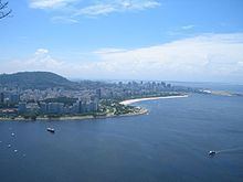 | ||
Flamengo is a neighborhood in Rio de Janeiro, Brazil.
Contents
- Map of Flamengo Rio de Janeiro State of Rio de Janeiro Brazil
- History
- Characteristics
- Destinations
- Notable residents
- References
Map of Flamengo, Rio de Janeiro - State of Rio de Janeiro, Brazil
History
It is the Portuguese word for Flemish, and it was given to the nearby beach (Praia do Flamengo, Beach of the Flemish) because it was the place where the Dutch sailor Olivier van Noort tried to invade the city in 1599. At that time, the Dutchmen were called "Flemish" by the Portuguese.
Characteristics
It is located between Catete and Botafogo districts on the edge of Guanabara Bay. The beachfront area is dominated by the Brigadier Eduardo Gomes Park, built by Lota de Macedo Soares on nearly 300 acres (1.2 km²) of land reclaimed from the bay and completed in 1965. The park features gardens designed by well-known Brazilian landscape designer Roberto Burle Marx.
The district and surroundings are serviced by three subway stations: Flamengo, Largo do Machado and Catete, and many bus lines that link it to the rest of the city. It is fairly close to the city centre and offers excellent views of Pão de Açúcar (Sugarloaf Mountain) and the statue of Christ the Redeemer. Nowadays, it is mostly a middle-class residential neighborhood.
Its main streets are Senador Vergueiro, Marquês de Abrante and Praia do Flamengo.