
Country United States County Cheshire Time zone Eastern (UTC-5) Elevation 349 m Population 2,396 (2010) | Incorporated 1773 Area code(s) 603 Zip code 03447 Local time Sunday 2:28 PM | |
 | ||
Weather -7°C, Wind NW at 14 km/h, 30% Humidity | ||
Fitzwilliam is a town in Cheshire County, New Hampshire, United States. The population was 2,396 at the 2010 census. Fitzwilliam is home to Rhododendron State Park, a 16-acre (6.5 ha) grove of native rhododendrons that bloom in mid-July.
Contents
- Map of Fitzwilliam NH USA
- History
- Geography
- Demographics
- Education
- Sites of interest
- Notable people
- References
Map of Fitzwilliam, NH, USA
History
First granted as Monadnock No. 4 in 1752 by Colonial Governor Benning Wentworth, this was one in a line of eight towns settled by Scottish colonists. Incorporated in 1773 by Governor John Wentworth, the town was named for his cousin, William Fitzwilliam, 4th Earl Fitzwilliam. Two early grantees in Fitzwilliam were Matthew Thornton, signer of the Declaration of Independence, and James Reed, who would lead the 3rd NH Regt. at Bunker Hill. The community claims one of the oldest granite quarries in New Hampshire. Other industries included wood-working and yarn-making. The railroad would enter in 1848.
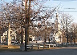
Fitzwilliam's picturesque common, together with twelve antique houses that surround it, are listed on the National Register of Historic Places.
Geography
According to the United States Census Bureau, the town has a total area of 36.0 square miles (93 km2), of which 34.6 sq mi (90 km2) is land and 1.4 sq mi (3.6 km2) is water, comprising 3.91% of the town. Little Monadnock Mountain, elevation 1,883 feet (574 m) above sea level, is the highest point in Fitzwilliam, located in the western part of town. The Metacomet-Monadnock Trail traverses the summit as does a shorter side trail from Rhododendron State Park. The town is drained by the South Branch of the Ashuelot River, the source of which is Bowker Pond. Fitzwilliam lies fully within the Connecticut River watershed.
The town is served by state routes 12 and 119.
Demographics
As of the census of 2000, there were 2,141 people, 836 households, and 586 families residing in the town. The population density was 61.8 people per square mile (23.9/km²). There were 1,074 housing units at an average density of 31.0 per square mile (12.0/km²). The racial makeup of the town was 97.52% White, 0.37% African American, 0.33% Native American, 0.19% Asian, 0.19% Pacific Islander, 0.05% from other races, and 1.35% from two or more races. Hispanic or Latino of any race were 0.75% of the population. 17.5% were of French, 16.6% English, 10.5% American, 10.5% Irish, 6.4% Italian, 6.0% Finnish, 6.0% German and 5.6% French Canadian ancestry according to Census 2000.
There were 836 households out of which 32.7% had children under the age of 18 living with them, 58.7% were married couples living together, 7.7% had a female householder with no husband present, and 29.9% were non-families. 22.4% of all households were made up of individuals and 7.4% had someone living alone who was 65 years of age or older. The average household size was 2.56 and the average family size was 3.02.
In the town, the population was spread out with 24.3% under the age of 18, 7.0% from 18 to 24, 28.2% from 25 to 44, 29.8% from 45 to 64, and 10.8% who were 65 years of age or older. The median age was 40 years. For every 100 females there were 103.3 males. For every 100 females age 18 and over, there were 104.0 males.
The median income for a household in the town was $48,125, and the median income for a family was $55,476. Males had a median income of $35,474 versus $29,130 for females. The per capita income for the town was $23,127. About 3.3% of families and 6.7% of the population were below the poverty line, including 9.2% of those under age 18 and 4.4% of those age 65 or over.
Education
Residents of Fitzwilliam attending public high school go to Monadnock Regional High School in Swanzey. Elementary school students attend Emerson Elementary School.