Samiksha Jaiswal (Editor)

Fiorano Modenese

Updated on
Edit
Like
Comment
Share on FacebookTweet on TwitterShare on LinkedInShare on Reddit
Country
  
Italy

Province / Metropolitan city
  
Modena (MO)

Demonym(s)
  
Fioranesi

Area
  
26.4 km²

Province
  
Province of Modena

Region
  
Emilia-Romagna

Elevation
  
115 m (377 ft)

Time zone
  
CET (UTC+1)

Postal code
  
41042

Local time
  
Sunday 4:16 AM

Fiorano Modenese httpsuploadwikimediaorgwikipediacommonsthu

Weather
  
6°C, Wind NW at 11 km/h, 64% Humidity

Fiorano Modenese is a comune (municipality) in the province of Modena in the Italian region Emilia-Romagna, located about 45 kilometres (28 mi) west of Bologna and about 15 kilometres (9 mi) southwest of Modena. Neighboring municipalities are Formigine, Sassuolo, Serramazzoni, Maranello.

Contents

Map of 41042 Fiorano Modenese, Province of Modena, Italy

Ferrari's private testing track, the Fiorano Circuit is located on the border with Maranello.
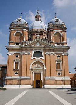
Main sights

  • Castle of Spezzano, noted from 11th century. It includes a frescoed gallery with scenes of battles fought by duke Alfonso I d'Este (1527-1531). At the lower floor is a hall with mid-16th century landscapes commissioned by Marco III Pio. A pentagonal tower once housed a prison and is now housed as a communal vinegar store.
  • Sanctuary of the Beata Vergine del Castello di Fiorano
  • Parish church of San Giovanni Battista
  • Oratorio di San Rocco, Spezzano
  • Museum of Ceramic
  • Church of San Lorenzo, Nirano
  • Salse of Nirano
  • Theater Astoria
  • Villas: Villa Campori, Villa Pace, Villa Guastalla, Villa Coccapani, Villa Cuoghi, Villa Messori.
  • Municipal vinegar factory
  • Districts

    The municipality of Fiorano Modenese is divided on 4 districts: Fiorano Modenese, Spezzano, Ubersetto and Nirano.

    Twin towns

  • Onda, Spain
  • Nardò, Italy
  • References

    Fiorano Modenese Wikipedia