
Local time Saturday 3:32 AM | ||
 | ||
Weather -9°C, Wind SW at 10 km/h, 100% Humidity Points of interest | ||
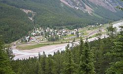
Field is an unincorporated community of approximately 169 people located in the Kicking Horse River valley of southeastern British Columbia, Canada, within the confines of Yoho National Park. It is 27 km (17 mi) west of Lake Louise along the Trans-Canada Highway which provides the only road access to the town.
Contents
Map of Field, BC, Canada
Town Site Administration
Field’s land ownership was originally split between the Crown and the Canadian Pacific Railway, with the border between the two jurisdictions being Stephen Avenue. The railroad was in charge of the water and electricity supply for the town until the 1950s, when the Canadian government took over. Today, the town site is managed by Parks Canada. Local residents lease their land from the park administration, with a term of 42 years.
The Burgess Shale
It was CPR train track workers in Field who discovered the fossils of the Burgess Shale locality. Commonly called by the workers ‘the stone bugs’, the very first fossils were discovered on Mt. Stephen. In 1909, Charles D. Walcott discovered the Walcott Quarry on the slope of Mt. Field.