
Deactivated 2006 Height 16 m Focal height 162 m | Construction masonry tower Opened 1886 Year first constructed 1886 | |
 | ||
Location Janela, Santo Antão, Cape Verde Tower shape octagonal prism tower with balcony and gallery Markings / pattern white tower and lantern Range 17 nautical miles (31 km; 20 mi) Similar Farol de D Amélia, Farol da Ponta Preta, Pico da Cruz, Topo da Coroa, Ribeira Grande | ||
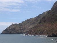
Farol de Fontes Pereira de Melo, better known as farol da ponta de Tumba ou do Tumbo (Tumba/Tumbo Lighthouse) or the Boi Lighthouse (farol de Boi) is a lighthouse in the northeastern point of the island of Santo Antão in northwestern Cape Verde near the settlement of Janela, it is located 10 km southeast of Vila das Pombas and 14.7 km norhtheast of Porto Novo. It is in the area of the island's easternmost part of the mountain range and belongs to Cova-Ribeira da Torre-Paul Natural Park. Its offers panoramic views of the island of São Vicente to the south. The lighthouse was named after Fontes Pereira de Melo, prime minister for several times between 1871 and 1886. Ponta de Tumba is 487 meters tall and about a kilometer wide.
Contents
Map of Fontes Pereira de Melo, Cape Verde
The lighthouse tower has a white octagonal shape with a lantern and a gallery, 16 meters high. Nearby is a building used for turning lighthouse light which is now abandoned and is in poor condition.
It was once connected with a track connecting with the Ribeira Grande-Janela Road. Recently, a new highway named the Estrada Littoral (Ribeira Grande-Janela-Porto Novo Road) linking Janela and Porto Novo running within the Atlantic, runs not far from the lighthouse, construction spread in 2005 and in 2006, along with a tunnel opened, it was completed in 2009, it would be connected with a track connecting the newly opened highway. The new highway serves the northern with the southern and the western parts of the island without crossing through the partly treacherous mountain road linking Ribeira Grande and Porto Novo at the elevation of over 1,000 meters.