
Country United States County Franklin Time zone Eastern (UTC-5) Elevation 130 m Population 7,760 (2010) | Incorporated February 1, 1794 ZIP codes 04938, 04992, 04940 Area 144.6 km² | |
 | ||
Weather -1°C, Wind W at 23 km/h, 48% Humidity University | ||
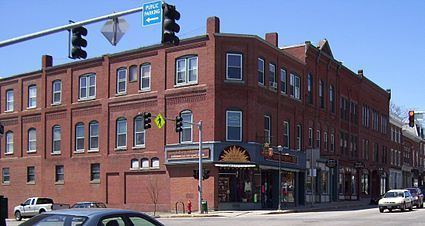
Historic downtown farmington maine
Farmington is a town in and the county seat of Franklin County, Maine, United States. As of the 2010 census, the town population was 7,760. Farmington is home to the University of Maine at Farmington, the Nordica Memorial Auditorium, the Homestead, and the annual Farmington Fair.
Contents
- Historic downtown farmington maine
- Map of Farmington ME USA
- History
- Geography
- Climate
- 2010 census
- 2000 census
- Government
- Sites of interest
- University of Maine At Farmington
- Neighborhoods
- Prophecy
- Notable people
- References
Map of Farmington, ME, USA
History
The area was once territory of the Canibas tribe of Abenaki Indians. They had two camps located near Farmington Falls, with fields cleared for cultivation of maize and potatoes. Their fort's stockade enclosed about an acre at the center of what is today Farmington Falls village. A group from Topsham arrived in 1776 to explore the area and lay out a town, called Plantation No. 1 or Sandy River Plantation, but permanent settlement was delayed by the Revolutionary War.
In 1781, the first settlers arrived, the same year a sawmill was established. On February 1, 1794, Sandy River Plantation was incorporated as Farmington, named for its unusually fertile soil. Beginning with a cluster of log houses at Farmington Falls, the town grew quickly and prospered. Agriculture was an important early occupation, with hay a principal product. Orchards yielded apples and other fruit. Farmington became one of the largest wool producing towns in New England, with many herds of sheep grazing the hills and intervales.
The town's water power attracted industry, including five lumber mills, two sash, blind and door factories, two brickyards, a foundry, a rake factory, three gristmills, nearly a dozen carriage factories, a cheese factory, two corn canning factories, two reaper machine factories, a spool factory and a tannery. As a regional center for manufacturing, trade and agriculture, Farmington was designated county seat when Franklin County was formed in 1838. In 1859, the Androscoggin Railroad completed its line from Leeds Junction to Farmington, carrying freight and tourists.
In 1879, the town became the southern terminus for the narrow gauge Sandy River Railroad (later part of the Sandy River and Rangeley Lakes Railroad), making it a gateway to the Rangeley Lake and Sugarloaf Mountain areas. Farmington suffered a devastating fire on October 22, 1886, when thirty-three houses, nineteen stores, three churches, the county jail and the post office were destroyed. The 1877 Methodist Church designed by noted architect Arthur H. Vinal survived. Farmington is today a college town and resort area.
Geography
According to the United States Census Bureau, the town has a total area of 55.82 square miles (144.57 km2), of which, 55.67 square miles (144.18 km2) of it is land and 0.15 square miles (0.39 km2) is water. Farmington is drained by Wilson Stream, Temple Stream, Beaver Brook and the Sandy River.
The town is crossed by U.S. Route 2 and Maine State Routes 4, 27, 43, 133, and 149. It borders the towns of Industry and New Sharon to the east, Chesterville to the south, Wilton to the southwest, Temple to the west, and Strong and New Vineyard to the north.
Farmington is divided up into four local areas and is sometimes mapped as such. These areas are West Farmington, Fairbanks, Farmington Falls, and Farmington (downtown). All areas except Fairbanks have their own zip code, but they are all still within Farmington's town limits.
Climate
Typically for Maine, Farmington has a humid continental climate (Köppen Dfb) with cold (sometimes severely cold) winters and warm, often humid summers. Winters are cold and snowy, with forty nights per year under 0 °F or −17.8 °C and 68.6 days failing to top freezing. Snow cover peaks in February at typically around 18 inches or 0.46 metres, but the maximum reached is 84 inches or 2.13 metres on February 28, 1969. The coldest month since records began in 1893 has been January 1982 with an average of 3.4 °F or −15.9 °C, and the hottest July 1921 with an average of 73.3 °F or 22.9 °C, including twelve days over 90 °F or 32.2 °C, whilst the coldest winter was that of 1917/1918 with an average temperature of 10.45 °F or −12.0 °C. The hottest day was August 3, 1975 which reached 101 °F or 38.3 °C, whilst the coldest temperature has been −39 °F or −39.4 °C on January 20, 1994.
Precipitation is abundant throughout the year, with snowfall especially heavy in winter – the wettest calendar month has been December 1969 with 15.49 inches or 393.4 millimetres including 41.0 inches (1.04 m) of snow and a fall from a warm front of 9.97 inches or 253.2 millimetres of precipitation (mostly rain) on December 27 and 28. The snowiest season was that from July 1968 to June 1969 with total snowfall of 164.0 inches or 4.17 metres, whilst the least snowy was from July 1980 to June 1981 with 43.0 inches or 1.09 metres.
2010 census
As of the census of 2010, there were 7,760 people, 3,072 households, and 1,597 families residing in the town. The population density was 139.4 inhabitants per square mile (53.8/km2). There were 3,441 housing units at an average density of 61.8 per square mile (23.9/km2). The racial makeup of the town was 96.9% White, 0.3% African American, 0.4% Native American, 0.3% Asian, 0.1% Pacific Islander, 0.3% from other races, and 1.7% from two or more races. Hispanic or Latino of any race were 1.3% of the population.
There were 3,072 households of which 23.1% had children under the age of 18 living with them, 38.2% were married couples living together, 9.9% had a female householder with no husband present, 3.9% had a male householder with no wife present, and 48.0% were non-families. 34.1% of all households were made up of individuals and 13% had someone living alone who was 65 years of age or older. The average household size was 2.17 and the average family size was 2.75.
The median age in the town was 32.1 years. 16% of residents were under the age of 18; 27.2% were between the ages of 18 and 24; 18.3% were from 25 to 44; 23.3% were from 45 to 64; and 15.5% were 65 years of age or older. The gender makeup of the town was 45.3% male and 54.7% female.
2000 census
As of the census of 2000, there were 7,410 people, 2,813 households, and 1,533 families residing in the town. The population density was 132.8 people per square mile (51.2/km2). There were 3,048 housing units at an average density of 54.6 persons/sq mi (21.1 persons/km2). The racial makeup of the town was 97.48% White, 0.20% African American, 0.30% Native American, 0.65% Asian, 0.03% Pacific Islander, 0.40% from other races, and 0.94% from two or more races. 0.82% of the population were Hispanic or Latino of any race.
There were 2,813 households out of which 24.8% had children under the age of 18 living with them, 42.5% were married couples living together, 9.1% have a woman whose husband does not live with her, and 45.5% were non-families. 31.7% of all households were made up of individuals and 11.8% had someone living alone who was 65 years of age or older. The average household size was 2.25 and the average family size was 2.87.
In the town, the population was spread out with 18.4% under the age of 18, 25.0% from 18 to 24, 21.5% from 25 to 44, 19.3% from 45 to 64, and 15.9% who were 65 years of age or older. The median age was 32 years. For every 100 females there were 81.0 males. For every 100 females age 18 and over, there were 75.1 males.
The median income for a household in the town was $26,814, and the median income for a family was $33,656. Males had a median income of $27,569 versus $21,101 for females. The per capita income for the town was $13,982. About 18.0% of families and 22.6% of the population were below the poverty line, including 30.6% of those under the age of 18 and 5.4% ages 65 or older.
Government
Farmington is the largest town, and county seat, of Franklin County. As a result, it has a number of regional administrative buildings such as a courthouse and DHHS branch. It is governed by a board of selectmen who meet at Town Hall on alternating Tuesdays at 6:30 PM. Daily administration is by a town manager, and the town holds an annual town meeting in March.
Sites of interest
Farmington is home to a number of historic properties and districts. These include the Cutler Memorial Library, Farmington Historic District, First Congregational Church, United Church of Christ, Franklin County Courthouse, Free Will Baptist Meetinghouse, Greenacre, Chester Greenwood House, Merrill Hall, Nordica Homestead, Old Union Meetinghouse, Hiram Ramsdell House and the Tufts House.
University of Maine At Farmington
Farmington is home to The University of Maine at Farmington, part of Maine's Public University system. UMF had a full-time enrollment of 1,800 in 2016.
Neighborhoods
Prophecy
Farmington is the subject of a prophecy by the Quaker Licia Kuenning (formerly Lisa Bieberman) about a Coming New Order in the town. This was originally prophesied for Tuesday 6 June 2006 but, after gathering more than 80 people together with no apparent miracles on that date, is now prophesied "within the next few years".