
Existed: 1951 – present East end: SH 321 in Dayton Constructed 1951 | West end: SH 6 Length 75.55 km | |
 | ||
Counties Harris County, Texas, Liberty County, Texas | ||
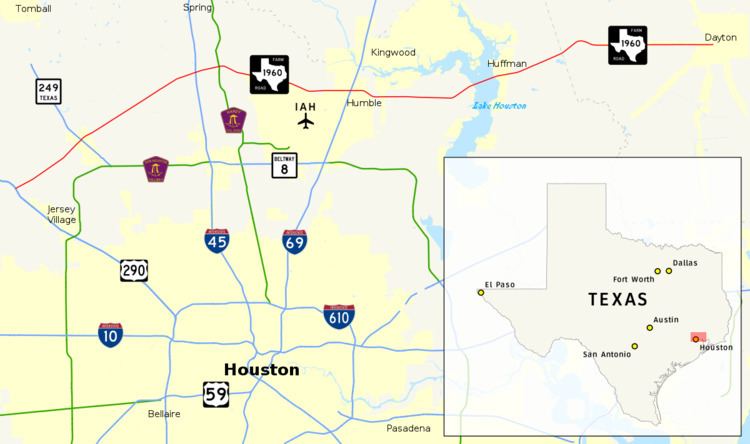
Farm to Market Road 1960 (FM 1960) is a state highway (or farm-to-market road) in the U.S. state of Texas. Its western terminus is at an intersection with U.S. Highway 290 and State Highway 6 in northwestern Harris County and travels generally to the east, ending at State Highway 321 in Dayton in western Liberty County.
Contents
- Map of FM 1960 Texas USA
- Historic western termini
- Historic eastern termini
- Humble business loop
- Major intersections
- References
Map of FM 1960, Texas, USA
FM 1960 has long been an artery around Houston, though it has been shortened and re-routed over the years. Once consisting of most of the current State Highway 6 in West Houston as well as its current northern route, it still serves many residents north of the Houston city limits, bordering 26 zip codes.
In 1995, FM 1960 was divided into two sections – the more rural part east of FM-2100 remaining with the Farm to Market designation and the one closer to the city west of FM-2100 was given the new Urban Road designation. This is mainly a Texas Department of Transportation convention, as all of the signage on the complete road retains its FM roots. In 2011, a large segment of FM 1960 was alternatively designated as Cypress Creek Parkway from State Highway 249 to Aldine-Westfield in an effort to improve the image of the roadway. Landscaped medians with designated turnlanes replaced the broad open center median originally in place.
FM 1960 is also one of the very few FM roads with a business segment, running through the middle of Humble, Texas.
Historic western termini
Historic eastern termini
a road intersection at Bammel (1951-1952) 6.6 Miles east of U.S. Highway 59 (1952–1956)
Humble business loop
Business Farm to Market Road 1960-A or Bus. FM 1960-A is an east-west business route of FM 1960. It is 4.1 miles (6.6 km) long and is one of the only three Business Farm to Market Roads in Texas. The road begins in Houston northeast of George Bush Intercontinental Airport and continues through central Humble where it intersects I-69/US 59 then reconnects to FM 1960 east of Humble. The route is known as Humble Westfield Rd. west of I-69/US 59 and First St. east of I-69/US 59.
The route follows a previous alignment of FM 1960 through Humble before 1978 when FM 1960 was redirected over its present location with the former alignment being then designated State Highway Loop 184. It retained the state loop designation until the current business route was established in 1990.
Major intersections
The entire route is in Harris County.