
OSI/OSNI grid D180438 Province Ulster | Topo map OSNI Discoverer 5 Elevation 196 m | |
 | ||
Similar Tievebulliagh, Scawt Hill, Black Mountain, Divis, Cavehill | ||
Day one at the fair head climbing meet climbing daily ep 722
Fair Head or Benmore (from Irish: an Bhinn Mhór) is a rocky headland at the north-eastern corner of County Antrim, Northern Ireland. It lies 3 miles (5 km) east of Ballycastle town, and is the closest part of the mainland to Rathlin Island. Geography books have long measured the length of Ireland "from Fair Head to Mizen Head". It is a very highly regarded rock-climbing location, and is believed to be the biggest expanse of climbable rock in the British Isles.
Contents
- Day one at the fair head climbing meet climbing daily ep 722
- Map of Fair Head Ballycastle UK
- North antrim coast fair head
- SettingEdit
- ClimbingEdit
- HistoryEdit
- LayoutEdit
- VisitingEdit
- References
Map of Fair Head, Ballycastle, UK
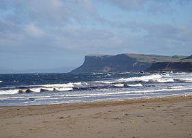
North antrim coast fair head
SettingEdit
The headland of Fair Head rises 196m above the sea. Wild goats can be seen roaming among the rocks beneath the clifftops, where a walkway called The Grey Man's Path winds around the rugged coastline. From the road, a manmade Iron Age island or crannóg can be seen in the middle of a lake, Lough na Cranagh. The lakes are stocked with trout and can be fished during the summer months. All of the land at Fair Head is private farm land, and not owned by National Trust. Access is by the good will of local farm owners.
Many famous Irish artists have painted Fair Head including Maurice Canning Wilks who painted a watercolour from a nearby beach.
ClimbingEdit
Fair Head is widely regarded as Ireland's finest climbing crag, but for a variety of reasons including its relatively remote location and the physical strength and unfamiliar climbing techniques often required there, does not attract the volume of climbers that one might expect at a crag of such quality. Its cliffs stretch for a distance of over 5 km around the headland, rising to a maximum height of over 100m. They are not sea-cliffs, but have been described as a mountain crag by the sea, since they tower above an extensive boulder field and their isolation and size gives climbing there a big-wall mountaineering feel.
The cliffs are composed of dolerite, giving a mixture of steep cracked walls, corners, and, in many places, sets of columns reminiscent of organ-pipes. The dolerite sits on top of a bed of chalk which is visible in places.
The cliffs abound in well-protected steep crack climbing, between one and four pitches long. Many of the cracks involve hand-jamming, so some climbers tape their hands to protect the skin from what they term "Fair Head rash". Other climbs involve off-width or full-width chimneying, which is not often encountered in other Irish crags. As with nearly all Irish crags, only Traditional protection ("clean climbing") is used.
The current guidebook, published in 2002, lists about 400 routes from under grade VS 4c up to E6 6b, but more recent climbing includes routes up to E8 6c.
HistoryEdit
The first climbs at Fair Head were done in the mid-1960s by some Belfast-based climbers and members of the Dublin-based Spillikin Club. Most of these climbs followed loose and dirty chimneys and are rarely repeated nowadays, but the seed had been planted, and before the end of the sixties development of the crag had started in earnest. However, it was not long before the increasing political violence in the North started making its presence felt; the Fair Head area was generally unaffected, but development of the crag slowed to a trickle during the early 1970s. However the attractions of Fair Head eventually proved irresistible and development picked up again in the late seventies, led by the husband-and-wife team of Calvin Torrans and Clare Sheridan and a number of other Dublin climbers. This small band devoted themselves to developing Fair Head, founded the Dal Riada Climbing Club (named after the ancient kingdom which included this area), and acquired a climbing hut nearby to accommodate themselves and other visiting climbers. There is still unclimbed rock at Fair Head; opportunities, mainly in the higher grades, are waiting for those who have the talent and dedication.
LayoutEdit
The cliffs are divided into several main sectors. From east to west, these are:
VisitingEdit
The Dal Riada Climbing Club formerly had the use of a series of buildings which they operated as climbing huts which they used to accommodate themselves and other visiting climbers, but this ended in 2007 when the last one was repossessed by its owners, the National Trust [1]. The most popular options now are either camping at a nearby campsite operated by a local farmer, or staying at a hostel in Ballycastle town, where there is a selection of bars and restaurants.