
Highest point Mount Sidley | Continent Antarctica Elevation 4,285 m Country Antarctica | |
 | ||
Mountains Mount Sidley, Mount Waesche, Mount Hampton | ||
The Executive Committee Range is a mountain range consisting of five major volcanoes, which trends north-south for 80 km (50 mi) along the 126th meridian west, in Marie Byrd Land, Antarctica.
Contents
Discovered by the United States Antarctic Service expedition on a flight, December 15, 1940, and named for the Antarctic Service Executive Committee. Individual mountains (e.g. Hampton, Waesche) are named in honor of members of the committee, except for Mount Sidley, the most imposing mountain in the range, which was discovered and named by Rear Admiral Byrd in 1934. The entire range was mapped in detail by USGS from surveys and U.S. Navy trimetrogon photography, 1958-60.
Mountains of this range include Mount Sidley, Mount Waesche and Mount Hampton.
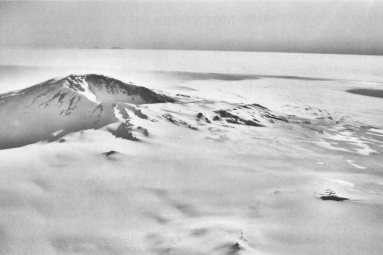
Mount Cumming
Mount Cumming (76°40′S 125°48′W) is a low, mostly snow-covered mountain, volcanic in origin, located midway between Mount Hampton and Mount Hartigan. A circular snow-covered crater occupies the summit area. Discovered by the U.S. Antarctic Service (USAS) (1939–41) on a flight, Dec. 15, 1940, and named for Hugh S. Cumming, Jr., State Department member of the U.S. Antarctic Service (USAS) Executive Committee. Mapped by U.S. Geological Survey (USGS) from surveys and U.S. Navy trimetrogon photography, 1958-60.
Mount Hartigan
Mount Hartigan (76°52′S 126°00′W) is a broad, mostly snow-covered mountain with several individually named peaks which rise up to 2,800 metres (9,186 ft), situated immediately north of Mount Sidley. Discovered by the United States Antarctic Service expedition on a flight, Dec. 15, 1940, and named for Rear Admiral Charles C. Hartigan, U.S. Navy (USN), Navy Department member of the Antarctic Service Executive Committee.
Le Vaux Peak
Le Vaux Peak (76°40′S 125°43′W) is a small peak on the east side of the crater rim of Mount Cumming. Mapped by United States Geological Survey (USGS) from surveys and U.S. Navy aerial photographs, 1958-60. Named by Advisory Committee on Antarctic Names (US-ACAN) for Howard A. Le Vaux, auroral physicist at Byrd Station, 1959, and a member of the Marie Byrd Land Traverse Party, 1959-60.
Recent and Ongoing Magmatism
In November 2013, Lough et al. reported deep long period volcanic earthquakes centered at depths of 30-40 km approximately 55 km S of Mount Sidley that were interpreted as indications of present deep crustal magmatic activity beneath the Executive Committee Range. Ice penetrating radar results reported in this study indicated a sub-ice topographic feature, interpreted as a volcano, above the seismic swarms. The study also reported a mid-icecap (1400 m depth) ash layer about 8,000 years old that was interpreted as probably originating at nearby Mount Waesche.