
Basin size 171 km² | Length 31 km | |
 | ||
Progression | ||
The Eula is a tributary of the River Wyhra in northwestern Saxony in Germany. It has a length of 31 kilometres and a catchment area of about 171 km².
Contents
Map of Eula, Germany
CourseEdit
The Eula rises in the Eulawäldchen ("Little Eula Wood") south of the Geithain parish of Wickershain. It crosses the municipality of Geithain, flowing through the lido of Oberfürstenteich. Beyond Geithain it collects the Salzbach from the left and the Kalkbach from the right. After passing through Niedergräfenhain, Frauendorf and Hermsdorf it reaches Prießnitz. Here it is joined from the right by the Frankenheimer Bach and the Little (Kleine) Eula. Next it flows through Flößberg and Beucha to Kitzscher, collecting the Heinersdorfer Bach and Steingrundbach before reaching Beucha.
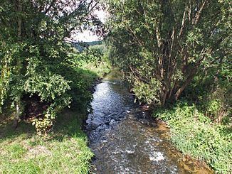
Whilst the Eula has been straightened for long stretches, there is a near natural reach between Beucha and Kitzscher with meanders, sand banks and kolks.
After collecting the Jordanbach in Kitzscher it turns from its hitherto predominantly northwesterly course to head in a southwestern to western direction. Flowing past Braußwig, Dittmannsdorf and Eula, where since 2009 it has once more flowed for half a kilometre on its old, winding riverbed, the river passes under the B 95 federal road. It then continues between Haubitz and the Witznitz Storage Basin and after 31 kilometres empties near Großzössen into the Wyhra, which then reaches its confluence with the Pleiße after just two more kilometres.