
Admin. region Oberbayern Municipal assoc. Unterammergau Local time Wednesday 5:43 PM | Elevation 877 m (2,877 ft) Population 801 (31 Dec 2008) | |
 | ||
Weather 4°C, Wind SW at 6 km/h, 70% Humidity Points of interest Linderhof Palace, Ettal Abbey, Park Linderhof, Königshäuschen | ||
Ettal is a German municipality in the district of Garmisch-Partenkirchen, in Bavaria.
Contents
Map of 82488 Ettal, Germany
Geography
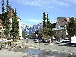
Ettal is situated in the Oberland area in the Graswangtal between the Loisachtal and Ammertal, approx. 10 km north of Garmisch-Partenkirchen, the district capital, and approx. 4 km southwest of Oberammergau.
Division of the town
The town consists of 5 districts
References
Ettal Wikipedia(Text) CC BY-SA