
 | ||
Bridges Arenal Bridge, Puente de Róntegui Similar Nervión, Vizcaya Bridge, Museo Marítimo Ría de Bil, The Euskalduna Conferen, Guggenheim Museum - Bilbao | ||
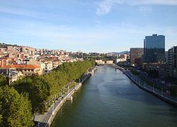
The Estuary of Bilbao (Spanish: Ría de Bilbao / Basque: Bilboko Itsasadarra) lies at the common mouth of the rivers Nervion, Ibaizabal and Cadagua, that drain most of Biscay and part of Alava in the Basque Country, Spain. In this instance, the Spanish word estuario is used to describe what in English would normally be called part estuary, part tidal river. The estuary becomes a tidal river which extends 16 km (9.9 mi) into the city of Bilbao, starting from the Bilbao Abra bay. It hosts the port of Bilbao throughout its length, although the Port Authority has recently restored most of the upper reaches to Bilbao and other municipalities for their urban regeneration. The port is now being transferred to the seaboard on the coast at Santurtzi and Zierbena.
Contents
Map of R%C3%ADa de Bilbao, Spain
Downstream from Bilbao the river divides its metropolitan area in its left bank (Barakaldo, Sestao, Portugalete and Santurtzi and its right bank (Erandio, Leioa and Getxo).
The recovery of the estuary
The estuary and tidal river of Bilbao have always been a significant part of the city. Bilbao was born 700 years ago on the banks of the river Nervión as a trading village. It gradually expanded downstream until arriving at the sea.
Unfortunately, the river reached high levels of contamination because of the industrial activities during the past century.
see page:http://bilbaoenconstruccion.com/2010/07/06/bilbao-recupera-su-alma-plan-integral-de-saneamiento-de-la-ria/