
Country United States County Wabaunsee FIPS code 20-21650 Area 135 ha Zip code 66423 Local time Tuesday 5:25 PM | Time zone Central (CST) (UTC-6) GNIS feature ID 0476925 Elevation 433 m Population 527 (2013) Area code 785 | |
 | ||
Weather 15°C, Wind W at 34 km/h, 12% Humidity | ||
Eskridge is a city in Wabaunsee County, Kansas, United States. As of the 2010 census, the city population was 534.
Contents
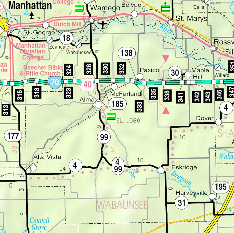
- Map of Eskridge KS 66423 USA
- History
- Geography
- Climate
- Demographics
- 2010 census
- 2000 census
- Education
- References
Map of Eskridge, KS 66423, USA
History
Eskridge was laid out in 1868. The town experienced growth in 1880 when the railroad was built through it.
Eskridge is named for Charles V. Eskridge, an Emporia, Kansas journalist and politician. Colonel Ephraim Sanford, the founder of the town company allowed Eskridge to buy the first lot and have the town named after him. Eskridge served in both houses of the legislature and was elected as lieutenant governor under Governor James M. Harvey in 1869.
In 1943, German and Italian prisoners of World War II were brought to Kansas and other Midwest states as a means of solving the labor shortage caused by American men serving in the war effort. Large internment camps were established in Kansas: Camp Concordia, Camp Funston (at Fort Riley), Camp Phillips (at Salina under Fort Riley). Fort Riley established 12 smaller branch camps, including one west of Eskridge at Lake Wabaunsee.
Geography
Eskridge is located at 38°51′31″N 96°6′27″W (38.858537, -96.107619). According to the United States Census Bureau, the city has a total area of 0.52 square miles (1.35 km2), all of it land.
Climate
The climate in this area is characterized by hot, humid summers and generally mild to cool winters. According to the Köppen Climate Classification system, Eskridge has a humid subtropical climate, abbreviated "Cfa" on climate maps.
Demographics
Eskridge is part of the Topeka, Kansas Metropolitan Statistical Area.
2010 census
As of the census of 2010, there were 534 people, 187 households, and 124 families residing in the city. The population density was 1,026.9 inhabitants per square mile (396.5/km2). There were 233 housing units at an average density of 448.1 per square mile (173.0/km2). The racial makeup of the city was 96.6% White, 1.1% African American, 0.2% Asian, 0.4% from other races, and 1.7% from two or more races. Hispanic or Latino of any race were 0.7% of the population.
There were 187 households of which 32.6% had children under the age of 18 living with them, 51.3% were married couples living together, 11.8% had a female householder with no husband present, 3.2% had a male householder with no wife present, and 33.7% were non-families. 26.2% of all households were made up of individuals and 9.6% had someone living alone who was 65 years of age or older. The average household size was 2.53 and the average family size was 3.08.
The median age in the city was 42.7 years. 24% of residents were under the age of 18; 6.8% were between the ages of 18 and 24; 21.6% were from 25 to 44; 31.3% were from 45 to 64; and 16.1% were 65 years of age or older. The gender makeup of the city was 48.1% male and 51.9% female.
2000 census
As of the census of 2000, there were 589 people, 212 households, and 146 families residing in the city. The population density was 1,145.2 people per square mile (445.9/km²). There were 238 housing units at an average density of 462.7 per square mile (180.2/km²). The racial makeup of the city was 97.28% White, 1.02% African American, 0.68% Native American, 0.34% Asian, 0.34% from other races, and 0.34% from two or more races. Hispanic or Latino of any race were 1.36% of the population.
There were 212 households out of which 31.6% had children under the age of 18 living with them, 53.8% were married couples living together, 9.9% had a female householder with no husband present, and 31.1% were non-families. 27.8% of all households were made up of individuals and 13.7% had someone living alone who was 65 years of age or older. The average household size was 2.50 and the average family size was 3.01.
In the city, the population was spread out with 23.3% under the age of 18, 7.8% from 18 to 24, 24.6% from 25 to 44, 24.8% from 45 to 64, and 19.5% who were 65 years of age or older. The median age was 40 years. For every 100 females there were 96.3 males. For every 100 females age 18 and over, there were 91.5 males.
The median income for a household in the city was $37,917, and the median income for a family was $43,125. Males had a median income of $29,688 versus $18,125 for females. The per capita income for the city was $12,629. About 7.7% of families and 13.9% of the population were below the poverty line, including 14.4% of those under age 18 and 23.4% of those age 65 or over.
Education
Eskridge is served by USD 330 Mission Valley. School unification consolidated Eskridge and Harveyville schools forming USD 330 Mission Valley. Mission Valley High School is located a few miles outside Eskridge in a rural area. The Mission Valley High School mascot is Mission Valley Vikings.
Eskridge High School was closed through school unification. Its last class graduated in 1971. The Eskridge High School mascot was Eskridge Dragons.