
 | ||
Governing body National Parks and Wildlife Service (Ireland) | ||
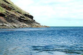
Erris Head (Irish: Ceann Iorrais) is a promontory at the northernmost tip of the Mullet Peninsula, located in the barony of Erris in northwest County Mayo, Ireland. It is a well known and recognised landmark used by mariners and weather forecasters, and is also a scenic viewpoint, with an unobstructed view of the Atlantic Ocean and steep rocky cliffs. It is not served by any road and can only be reached by crossing a number of fields.
Contents
Map of Erris Head, Illandavuck, Ireland
Special Area of Conservation
Erris Head is a European Union Special Area of Conservation (SAC). Erris Head SAC comprises approximately 15 km (9.3 mi) of cliff plus adjoining habitats. The geology of the region consists of acid rocks, such as quartzite, gneiss and Silurian schists and slates. The sea cliffs are very exposed and subject to very high rainfall. They are of moderate height, reaching a maximum of about 90 m (300 ft) in the north-east and are predominantly north-facing. A notable habitat on the site is alpine heath, which occurs inland from the tops of the sea cliffs.
Marine reserve
An area of sea, extending 200 m (660 ft) from the base of the cliffs, forms part of the site. This is included mainly to provide added protection for the cliff-nesting seabirds.