
State/Province DE-ST Mountain range Harz | Elevation 848 m | |
 | ||
Similar Hohnekamm, Heinrichshöhe, Königsberg, Barenberg, Wolfsklippen | ||
The Erdbeerkopf is an 847.7 m-high mountain in the High Harz in central Germany, northeast of Schierke in the state of Saxony-Anhalt.
Map of Erdbeerkopf, 38879 Wernigerode, Germany
To the north and east, the forested summit is bordered by the Wormsgraben, the valley of the Wormke. To the south runs the Brocken Railway along the slopes of the Erdbeerkopf.
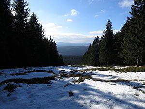
There are two paths leading to the mountain, from the east and west. To the southwest a field runs downhill that used to be a ski slope. The remains of a derelict ski lift can still be seen there. The mountain is very rarely climbed despite its accessible location. On the summit is a wooden bench from where part of the South Harz can be seen through the gap in the trees.
References
Erdbeerkopf Wikipedia(Text) CC BY-SA