
 | ||
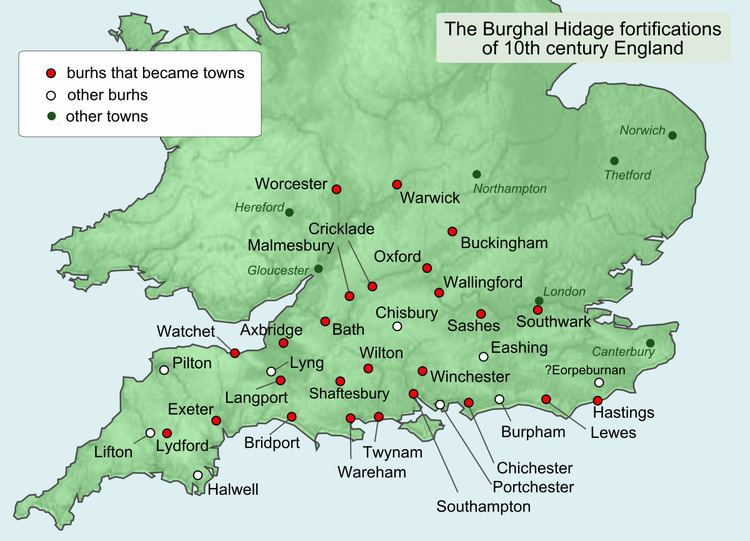
Eorpeburnan is the first place identified in the Burghal Hidage, a document created in the late 9th or early 10th century, that provides a list of thirty three fortified places mainly in Wessex. It details the location of fortifications designed to defend the West Saxon kingdom from the Vikings but also the relative size of burghal defences and their garrisons. Eorpeburnan is designated as having a hidage of 324, its precise location is lost in history, but scholars have suggested some possible sites.
Contents
Background
Eorpeburnan is the first of thirty three fortified places (burhs) in the ancient Kingdom of Wessex, that is listed on a document that has come to be known as the Burghal Hidage. The document that was created in the late 9th or early 10th century was named by Frederic William Maitland in 1897. The network of burhs, listed in the Burghal Hidage, was part of Alfred the Great's response to a series of raids and invasions by the Vikings.
The location of the burhs were chosen to defend the main road and river routes into Wessex from Viking attack. They were also a place of refuge, being sited such that any of the Anglo-Saxon rural population would be no more than 20 miles (32 km) from their nearest burh. In addition the burhs became secure regional market centres and a place to mint coins, particularly after 973 when the coinage was reminted every five years or so.
Eorpe~ the first element of the name Eorpeburnan is possibly a personal name or the Old English for dark and the ~burnan probably means stream.
Modern location of Eorpeburnan
Although the location of Eorpeburnan is not known for sure, the various fortifications in the hidage are approximately 40 miles apart and they are listed, in a clockwise direction, around Wessex with Eorpeburnan being the first. Thus the location for Eorpeburnan can be approximated.
Castle Toll
The Anglo-Saxon Chronicle records that in the year 892 a 'great host of the Danes came up into the estuary of the Limen (now the River Rother), with two hundred and fifty ships' it further describes how they stormed a half finished fortress. It is possible that the fort described by the chronicle is Castle Toll, Newenden in Kent. However, some historians have argued against Castle Toll being Eorpeburnan as the Burghal hidage does not provide for the defence of Kent.
Rye
The town of Rye has also been suggested as the site of Eorpeburnan. Rye is in Sussex and the hidage makes provision for the defence of Sussex. The second location listed in the Burghal Hidage is westwards of Rye at Hastings. However, there is no firm evidence of Anglo-Saxon occupation in the Rye area, if any Saxon work existed, no trace remains now. An excavation in the 1980s revealed the remains of a ditch, although it was not possible to date it. A more extensive survey was carried out in the 19th century in the town ditch area, when more of the archaeology was intact. It has been possible to deduce the length of wall for each of the listed burhs based on the figures provided by the hidage. The length of the town ditch, in Rye, equates well to the hidage, listed for Eorpeburnan.