
Admin. region Detmold Elevation 107 m (351 ft) Area 41.21 km² Local time Friday 7:45 PM Administrative region Detmold | Time zone CET/CEST (UTC+1/+2) Population 20,010 (31 Dec 2010) Postal code 32130 | |
 | ||
Weather 7°C, Wind NE at 2 km/h, 72% Humidity | ||
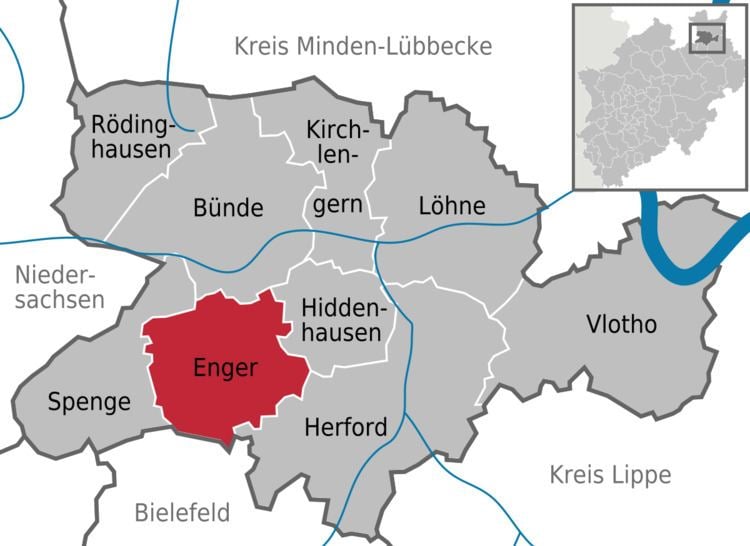
Enger is a town in the Herford district, in North Rhine-Westphalia, Germany.
Contents
- Map of 32130 Enger Germany
- Geography
- Neighbouring places
- Division of the town
- History
- Sons and daughters of the town
- References
Map of 32130 Enger, Germany
Geography
Enger is situated between the Teutoburg Forest and the Wiehen Hills, approx. 6 km west of the town of Herford, the capital of the district.
Neighbouring places
Division of the town
Enger consists of the following districts (population as of December 31, 2005):
History
The town, first mentioned in 948, calls itself "Widukind's town." The Saxon leader Widukind died about 808. However, there is no evidence that Enger existed in his lifetime.
A legend tells that Widukind founded a church in Enger after his baptism, and that he lived at the place until his death. He was buried in the church of Enger, and his monumental tomb is still there. Despite this, it remains doubtful that the remains of Widukind are actually in the tomb. Analysis shows that the memorial slab dates to the time around the year 1100.
The main current attractions of Enger are Widukind's tomb, the Widukind museum, the Widukind festival ("Timpkenfest"), held annually on January 6 and the "Kirschblütenfest".