
District Mombetsu Population 21,827 (Jul 2013) Local time Saturday 3:19 AM | Area 1,332 km² Flower Sunflowers | |
 | ||
Time zone Japan Standard Time (UTC+9) City hall address 1-1 1 Jō-Kita 3chōme, Engaru-chō, Hokkaido099-0403 Weather -5°C, Wind W at 6 km/h, 77% Humidity | ||
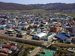
Engaru (遠軽町, Engaru-chō) is a town in the Monbetsu district of Okhotsk subprefecture in Hokkaido, Japan. The name comes from the Ainu place name inkar-us-i (lit. "overlook-always doing-place"), meaning a lookout point.
Contents
- Map of Engaru Monbetsu District Hokkaido Prefecture Japan
- History
- Notable geography
- Industry
- Climate
- Sister cities
- Notable people
- References
Map of Engaru, Monbetsu District, Hokkaido Prefecture, Japan
On October 1, 2005, the towns of Ikutahara and Maruseppu, and the village of Shirataki, all from Monbetsu District merged into the expanded town of Engaru. As of July 2013, the town has an estimated population of 21,827. The total area is 1,332.32 square kilometres (514.41 sq mi), making it the fifth largest municipality in Hokkaido.
Engaru is known as the place where Aikido originated, in the Shirataki area. It is also where the largest cosmos flower park in Japan is located. An Upper Paleolithic site at Shirataki Site Group is the source of some Yubetsu technique stone blades dating from approximately 13,000 years ago.
History
Notable geography
Industry
The major industries are commercial forestry, wood processing, and agriculture.
In the past, Engaru Station was the intersection of the Nayoro Main Line (closed in 1989) and the Sekihoku Main Line. It had an important position in business and overall development.
Climate
According to the Köppen climate classification, Engaru has a humid continental climate (Dfb) with warm summers and very cold winters.