
Length 12 km | Source elevation 131 m | |
 | ||
Main source Panguipulli Lakearound 131 m (430 ft) River mouth Riñihue Lakearound 105 m (344 ft) | ||
How to pronounce enco river spanish argentina pronouncenames com
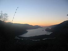
Enco River (Spanish: Río Enco) is a river in Panguipulli commune in southern Chile. By flowing from Panguipulli Lake to Riñihue Lake Enco River carries the water of the six upper lakes of the Seven Lakes area into Riñihue, the last lake in the chain. Located between the piedmont of Mocho-Choshuenco Volcano and Cerro Maltusado Enco River is unusual because it drains Panguipulli Lake through its eastern and mountainous end rather than allowing the lake to drain through the low moraine hills in the west.
Contents
- How to pronounce enco river spanish argentina pronouncenames com
- Map of Enco River Los RC3ADos Region Chile
- References
Map of Enco River, Los R%C3%ADos Region, Chile
The Enco flows for nearly eight miles from Panguipulli Lake to Riñihue Lake. This course of the river is made spectacular by the presence, in the east, of the magnificent volcano Volcan Mocho. This combination of scenic landscape, clear water and considerably safe waters have made the Enco a magnet for rafters and other white water aficionados.
The river has strong currents and no traffic.