
Country United States County Pottawatomie FIPS code 20-21100 Elevation 312 m Zip code 66422 Population 189 (2013) | Time zone Central (CST) (UTC-6) GNIS feature ID 0476257 Area 50 ha Local time Thursday 10:33 PM Area code 785 | |
 | ||
Weather 4°C, Wind N at 26 km/h, 55% Humidity | ||
Emmett is a city in Pottawatomie County, Kansas, United States. As of the 2010 census, the city population was 191.
Contents
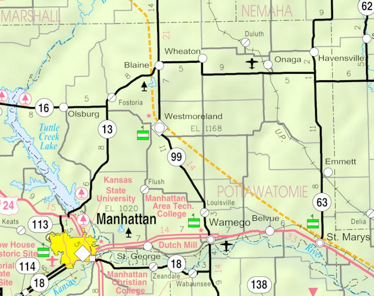
Map of Emmett, KS 66422, USA
History
The first post office in Emmett was established in November 1905. The community was named for Robert Emmet, an Irish nationalist.
Geography
Emmett is located at 39°18′26″N 96°03′23″W (39.307092, -96.056368). According to the United States Census Bureau, the city has a total area of 0.20 square miles (0.52 km2), all of it land.
Demographics
Emmett is part of the Manhattan, Kansas Metropolitan Statistical Area.
2010 census
As of the census of 2010, there were 191 people, 71 households, and 43 families residing in the city. The population density was 955.0 inhabitants per square mile (368.7/km2). There were 87 housing units at an average density of 435.0 per square mile (168.0/km2). The racial makeup of the city was 89.0% White, 1.6% African American, 1.6% Native American, 0.5% Pacific Islander, 0.5% from other races, and 6.8% from two or more races. Hispanic or Latino of any race were 10.5% of the population.
There were 71 households of which 36.6% had children under the age of 18 living with them, 47.9% were married couples living together, 2.8% had a female householder with no husband present, 9.9% had a male householder with no wife present, and 39.4% were non-families. 33.8% of all households were made up of individuals and 8.4% had someone living alone who was 65 years of age or older. The average household size was 2.69 and the average family size was 3.58.
The median age in the city was 27.2 years. 33.5% of residents were under the age of 18; 14% were between the ages of 18 and 24; 20.4% were from 25 to 44; 21.9% were from 45 to 64; and 9.9% were 65 years of age or older. The gender makeup of the city was 56.0% male and 44.0% female.
2000 census
As of the census of 2000, there were 277 people, 103 households, and 66 families residing in the city. The population density was 1,472.5 people per square mile (562.9/km2). There were 139 housing units at an average density of 738.9 per square mile (282.5/km2). The racial makeup of the city was 93.50% White, 5.42% Native American, and 1.08% from two or more races. Hispanic or Latino of any race were 1.44% of the population.
There were 103 households out of which 30.1% had children under the age of 18 living with them, 49.5% were married couples living together, 9.7% had a female householder with no husband present, and 35.0% were non-families. 29.1% of all households were made up of individuals and 8.7% had someone living alone who was 65 years of age or older. The average household size was 2.69 and the average family size was 3.40.
In the city, the population was spread out with 33.6% under the age of 18, 5.8% from 18 to 24, 28.5% from 25 to 44, 21.3% from 45 to 64, and 10.8% who were 65 years of age or older. The median age was 34 years. For every 100 females there were 103.7 males. For every 100 females age 18 and over, there were 109.1 males.
The median income for a household in the city was $27,778, and the median income for a family was $27,750. Males had a median income of $35,208 versus $14,750 for females. The per capita income for the city was $12,078. About 20.0% of families and 27.3% of the population were below the poverty line, including 46.3% of those under the age of eighteen and 17.1% of those sixty five or over.
Education
Emmett is a part of USD 321 Kaw Valley. High school students attend St. Marys Jr/Sr High School in St. Marys. The St. Marys High School mascot is Bears.
Emmett High School was closed through school unification. The Emmett High School mascot was Emmett Eagles.