
Country United States Incorporated 1869 Time zone CST (UTC-6) Zip code 66536 University St. Mary's College | Elevation 955 ft (291 m) Area 3.06 km² Population 2,677 (2013) | |
 | ||
Weather 11°C, Wind NW at 19 km/h, 93% Humidity | ||
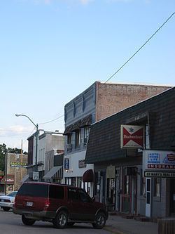
Sugar creek country store st marys kansas
St. Marys is a city in Pottawatomie and Wabaunsee counties in the U.S. state of Kansas. As of the 2010 census, the city population was 2,627.
Contents
- Sugar creek country store st marys kansas
- Map of St Marys KS 66536 USA
- Culture of st marys kansas
- History
- Geography
- Demographics
- 2010 census
- 2000 census
- Education
- References
Map of St Marys, KS 66536, USA
Culture of st marys kansas
History
St. Marys was laid out as a town in 1866. It was named after the St. Mary's Catholic Mission.
Geography
St. Marys is located at 39°11′47″N 96°4′7″W (39.196273, -96.068672), on the Smoky Hill Trail and the Military Trail. According to the United States Census Bureau, the city has a total area of 1.18 square miles (3.06 km2), all of it land.
The city is located approximately 20 miles west of Topeka on U.S. Route 24.
Demographics
Of the 1,240 people aged 25 and older, 89.5% had completed high school, 48.5% had completed at least some college, 13.4% had a BA, and 5.4% had an advanced or professional degree.
2010 census
As of the census of 2010, there were 2,627 people, 836 households, and 560 families residing in the city. The population density was 2,226.3 inhabitants per square mile (859.6/km2). There were 900 housing units at an average density of 762.7 per square mile (294.5/km2). The racial makeup of the city was 91.1% White, 1.1% African American, 1.4% Native American, 0.5% Asian, 2.3% from other races, and 3.6% from two or more races. Hispanic or Latino of any race were 9.0% of the population.
There were 836 households of which 37.6% had children under the age of 18 living with them, 54.4% were married couples living together, 9.0% had a female householder with no husband present, 3.6% had a male householder with no wife present, and 33.0% were non-families. 29.5% of all households were made up of individuals and 14.7% had someone living alone who was 65 years of age or older. The average household size was 3.10 and the average family size was 4.04.
The median age in the city was 26.8 years. 38.5% of residents were under the age of 18; 9.6% were between the ages of 18 and 24; 19.8% were from 25 to 44; 18.7% were from 45 to 64; and 13.6% were 65 years of age or older. The gender makeup of the city was 48.0% male and 52.0% female.
2000 census
As of the census of 2000, there were 2,198 people, 818 total households, and 525 families residing in the city. The population density was 1,987.1 people per square mile (764.6/km²). There were 818 housing units at an average density of 739.5 per square mile (284.5/km²). The racial makeup of the city was 95.18% White, 0.91% African American, 1.36% Native American, 0.50% Asian, 0.50% from other races, and 1.55% from two or more races. Hispanic or Latino of any race were 4.14% of the population.
There were 818 households out of which 35.5% had children under the age of 18 living with them, 56.8% were married couples living together, 9.2% had a female householder with no husband present, and 31.2% were non-families. 29.7% of all households were made up of individuals and 12.4% had someone living alone who was 65 years of age or older. The average household size was 2.83 and the average family size was 3.61.
In the city, the population was spread out with 35.4% under the age of 18, 7.6% from 18 to 24, 24.0% from 25 to 44, 17.9% from 45 to 64, and 15.0% who were 65 years of age or older. The median age was 31 years. For every 100 females there were 91.3 males. For every 100 females age 18 and over, there were 88.4 males.
The median income for a household in the city was $28,083, and the median income for a family was $28,063. Males had a median income of $25,595 versus $23,750 for females. The per capita income for the city was $15,536. About 26.2% of families and 31.1% of the population were below the poverty line, including 17.1% of those under age 18 and 27.2% of those age 65 or over.
It is part of the Manhattan, Kansas Metropolitan Statistical Area.
Education
Kaw Valley School District (USD 321) is located in St. Marys. Besides providing education from pre-K to 12 in St. Marys, it also services students in a four-county radius with four other attendance centers. Its high school is St. Marys High School.
A private school, St. Mary's Academy and College includes grades K-12 as well as a four-year college program. The Society of Saint Pius X operates the school.