
Type proglacial lake | Basin countries United States | |
 | ||
Location Utah County, Utah,
United States Primary inflows Similar Wasatch Range, Mount Timpanogos, Rocky Mountains, American Fork Canyon, Stewart Falls Trail | ||
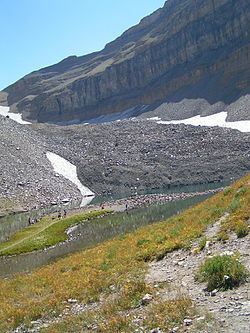
Emerald Lake is a small lake near the summit of Mount Timpanogos in Utah's Wasatch Range. It is northeast of the summit, at the base of the almost vertical northeast face of the mountain. The now mostly vanished and completely buried Timpanogos Glacier left behind a terminal moraine which now impounds the lake. The runoff from the rock glacier feeds the lake and colors it blue. The lake is accessible by hiking, the Aspen Grove trail being the fastest way to reach it; it is about 5 miles, (or two-thirds) up that trail on the way to the summit.
Map of Emerald Lake, Utah 84604, USA
References
Emerald Lake (Utah) Wikipedia(Text) CC BY-SA