
Type Tarn Basin countries United Kingdom Max. width 350 yd (320 m) Length 915 m Number of islands 2 | Primary outflows River Brathay Max. length 1,030 yd (940 m) Surface elevation 57 m Width 393 m Outflow location River Brathay | |
 | ||
Primary inflows Similar Lake District, River Brathay, Loughrigg Tarn, Little Langdale, Rydal Water | ||
A walk around elter water walks around britain shorts
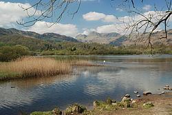
Elter Water is a small lake that lies half a mile (800 m) south-east of the village of Elterwater. Both are situated in the valley of Great Langdale in the English Lake District. The name Elterwater means either Lake of the Swan or Lake of Alder.
Contents
- A walk around elter water walks around britain shorts
- Map of Elter Water Ambleside UK
- Etymology
- References
Map of Elter Water, Ambleside, UK
The lake is 1030 yd (930 m) long and varies in width up to a maximum of 350 yd (320 m), covering an area of 0.06 mi² (0.15 km²). It has a maximum depth of 20 ft (6.1 m) and an elevation above sea level of 187 ft (57 m). The river Brathay which provides outflow from Elter Water flows south to join Windermere, near Ambleside.
Navigation is prohibited on the lake.
Etymology
" 'The lake frequented by swans', from ON 'elptr'/'alpt' 'swan', in the gen.[itive], sing.[ular] form with '-ar', and 'water', probably replacing ON 'vatn' 'lake'. Whooper swans still winter on the lake".(ON is Old Norse).