
Country United States County Allegheny ZIP codes 15088 Zip code 15088 Area code 412 | State Pennsylvania Time zone Eastern (EST) (UTC-5) Designated December 20, 1946 Population 1,485 (2013) Local time Thursday 1:49 AM | |
 | ||
Weather 9°C, Wind SW at 21 km/h, 32% Humidity Area 104 ha (78 ha Land / 26 ha Water) | ||
Activating learning in elizabeth pennsylvania
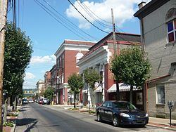
Elizabeth is a borough in Allegheny County, Pennsylvania, on the east bank of the Monongahela River, where Pennsylvania Route 51 crosses, 15 miles (24 km) upstream (south) of Pittsburgh and close to the county line. The population was 1,493 at the 2010 census. The borough of Elizabeth is entirely contained within the 15037 USPS ZIP code. The local school district is the Elizabeth Forward School District.
Contents
- Activating learning in elizabeth pennsylvania
- Map of Elizabeth PA 15037 USA
- Geography
- Demographics
- History
- Early industry
- Nike missile site
- References
Map of Elizabeth, PA 15037, USA
Geography
Elizabeth is located at 40°16′16″N 79°53′11″W (40.271189, -79.886347).
According to the United States Census Bureau, the borough has a total area of 0.4 square miles (1.0 km2), of which 0.3 square miles (0.78 km2) is land and 0.1 square miles (0.26 km2), or 14.63%, is water.
Demographics
As of the census of 2000, there were 1,609 people, 681 households, and 422 families residing in the borough. The population density was 4,544.8 people per square mile (1,775.0/km²). There were 758 housing units at an average density of 2,141.1 per square mile (836.2/km²). The racial makeup of the borough was 94.84% White, 3.60% African American, 0.37% Native American, 0.19% Asian, and 0.99% from two or more races. Hispanic or Latino of any race were 0.25% of the population.
Households: There were 681 households, out of which 26.9% had children under the age of 18 living with them, 44.6% were married couples living together, 11.9% had a female householder with no husband present, and 37.9% were non-families. 33.0% of all households were made up of individuals, and 17.8% had someone living alone who was 65 years or older. The average household size was 2.34 and the average family size was 2.98.
Age Distribution: The population was spread out, with 22.9% under the age of 18, 6.5% from 18 to 24, 28.5% from 25 to 44, 21.0% from 45 to 64, and 21.1% who were 65 or older. The median age was 40. For every 100 females, there were 82.2 males; for every 100 females age 18 and over, there were 79.1 males.
Income: The median income for a household in the borough was $30,556, and the median income for a family was $36,607. Males had a median income of $28,088 versus $22,350 for females. The per capita income for the borough was $17,618. About 7.3% of families and 10.2% of the population were below the poverty line, including 17.5% of those under age 18 and 8.8% of those age 65 or over.
History
Early industry
Among the earliest industries of Elizabeth were glass making, safe making, steamboat building, and ship building. The town had two coal inclines in 1876, the O'Neil and Company Coal Incline on pool 1, and the Lobb's Run Incline on pool 2.
Nike missile site
From 1956 to 1963, Elizabeth was the location of a Nike anti-aircraft missile site (40°15′17″N 79°57′59″W).