
Easiest route Hike | Elevation 1,604 m | |
 | ||
Location Tolga, Rendalen, Hedmark, Norway Parent range Nord Østerdalen - Femund Similar Sålekinna, Sølen, Håmmålsfjellet, Storsølnkletten, Tronfjell | ||
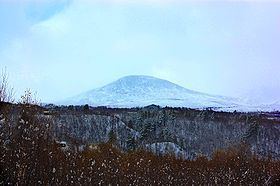
Elgpiggen is a mountain located within the municipalities of Tolga and Rendalen, (in Hedmark) in the Holøydalen mountain area. The mountain is easily recognizable due to its shape as a pyramid.
Contents
Map of Elgpiggen, 2485 Rendalen, Norway
NameEdit
"Elgpiggen" means "the peak (piggen) of the mountain of the Elk", which is seen as the king of all animals inhabiting the Norwegian forest.
AccessEdit
Access to Elgpiggen is possible all year around. In the summer you can choose a six-kilometre walk from Orvdalen or a seven-kilometer walk from Heggerådalen. The easiest way of climbing the mountain is from the northwest side. Here you will find hikes along the mountain side which will guide you up the last, but very steep part all the way to the top.
In the winter, cross-country skiing is the only possible way to reach the mountain. Here you may choose a longer route, 25 km, starting at Hodalen, a local, rural and cottage community. It is recommended though to go skiing here in the latter part of the winter season, due to problems with large amounts of snow in the area, making cross-country more difficult in unprepared terrain. Its steep pyramid shape makes Elgpiggen a perfect destination for off-piste skiing.
The viewEdit
From the top you can view other great peaks. In the west you will spot Snøhetta and Rondane while in the south you are able to see Rendalssølen with its three peaks.