
Archipelago Bahamas Highest elevation 61 m (200 ft) Area 518 km² Max width 1.6 km | Adjacent bodies of water Caribbean Max length 177 km Elevation 61 m Population 11,165 (2000) | |
 | ||
Districts North Eleuthera, Central Eleuthera, South Eleuthera Ethnic groups 85% black (esp. West African), 12% European, 3% other Points of interest Ten Bay Beach, Ocean Hole, Gaulding Cay Beach, Hatchet Bay Cave, Sky Beach Club | ||
Eleuthera island the real bahamas hd
Eleuthera /iˈluːθərə/ refers both to a single island in the archipelagic state of The Commonwealth of the Bahamas and to its associated group of smaller islands. Eleuthera forms a part of the Great Bahama Bank. The island of Eleuthera incorporates the smaller Harbour Island. "Eleuthera" derives from the feminine Greek adjective ἐλεύθερος (eleutheros), meaning "free". Known in the 17th century as Cigateo, it lies 80 km (50 miles) east of Nassau. It is long and thin—180 km (110 miles) long and in places little more than 1.6 km (1.0 mile) wide. Its eastern side faces the Atlantic Ocean, and its western side faces the Great Bahama Bank. The topography of the island varies from wide rolling pink sand beaches to large outcrops of ancient coral reefs, and its population is approximately 11,000. The principle economy of the island is tourism.
Contents
- Eleuthera island the real bahamas hd
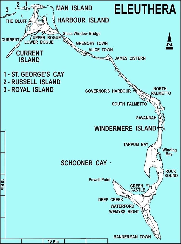
- Map of Eleuthera The Bahamas
- A visit to harbour island eleuthera bahamas
- Geography and wildlife
- History
- Demography
- Economy and Settlements
- Education
- Transport
- NAVFAC Eleuthera
- Eleuthera AAFB
- In popular culture
- References
Map of Eleuthera, The Bahamas
A visit to harbour island eleuthera bahamas
Geography and wildlife
The name Eleuthera refers both to the single Bahamian island and is also used to refer to its associated chain of small islands, which include Harbour Island, Windermere Island Man Island and Current Island. Eleuthera forms part of the Great Bahama Bank on its western edge and its eastern coastline faces the Atlantic Ocean. The main island lies 80 km (50 miles) east of Nassau. It is a long and thin island; 180 km (110 miles) long and little more than 1.6 km (1.0 mile) wide at its narrowest. The island has an estimated area of 457.4 square-kilometers, and presents 336 km (210 miles) of coastline.
The topography of the island varies, including wide rolling pink sand beaches, large outcrops of ancient coral reefs, caves and other geological features. The island features, among other flora and fauna, 13 catalogued species of native amphibian and reptile species, three of which were listed as endangered in 2000. The main island is home to a 25 acre nature preserve; the Leon Levy Native Plant Reserve, which includes an environmental education centre. The waters around Eleuthera contain an abundance of Sharks and Rays, which is attributed by the local Cape Eleuthera Institute to the banning of long-line fishing in local waters.
History
The islands first settlers are believed to have originated from the main continent of the Americas. This included the original population of Taino, or Arawaks. Following increasing Spanish visits after the discovery of the area by Christopher Colombus the local population either perished were diseased or are stated to have been deported by the Spanish to work in the mines of Hispaniola, where they died out by 1550. An intact wooden duho or ritual seat that was made by the Taino people was found on the island of Eleuthera in the nineteenth century and is now in the collections of the British Museum. The island in its early history was known as Cigateo, but this name changed following subsequent European settlement.
The island is believed to have been largely unoccupied until the first European settlers arrived in volume, with puritan pilgrims (who formed the previous year in London) arriving in 1648 from other parts of Bermuda. These settlers, known as the "Eleutherian Adventurers", under Captain William Sayle gave the island its current name - ἐλευθερία eleutheria which derives from the feminine form of the Greek adjective ἐλεύθερος, eleutheros, meaning "free". The difficulties of settlement ultimately left only a few of the settlers on the island, but had these Puritan pioneers succeeded in their aim, they would have created the first democracy in the Western Hemisphere, almost 130 years prior to the American Revolution.
The island was stated to have been agriculturally prosperous in the period from 1950 to 1980. This included a large crop of pineapples for exports. When the Bahamas became independent from Britain in 1973, new ownership laws changed the nature of the island economy. Since then the island has become a popular tourist destination.
In 1992 the island was severely damaged by the category 5 Hurricane Andrew; massive wind speeds hit the island and an 18 foot tidal surge inundated the coastal area. Relief efforts helped mitigate some of the damage, including a number of relief tasks that were carried out by HMS Cardiff as the vessel was operating in the area.
Demography
In 2000, the official census taken by the Government of the Bahamas recorded a population of 7,999 persons on the island. In 2010, the official census recorded the population as 8,202 spread across 2,718 separate households. The 2010 census stated that population density of the island was 57.6 persons, per square mile. As of 2017 it was stated that the population of the islands were approximately 11,000.
Economy and Settlements
Settlements on the island include (north to south) the Bluff, Upper and Lower Bogue, Current, Gregory Town, Alice Town, James Cistern, Governor's Harbour, North and South Palmetto Point, Savannah Sound, Winding Bay, Tarpum Bay, Rock Sound, Greencastle, Deep Creek, Delancy Town, Waterford, Wemyss Bight, John Millars, Millar's and Bannerman Town.
The largest of the settlements are Governor's Harbour (the administrative capital), Rock Sound, Tarpum Bay, Harbour Island with its unusual pink sandy beaches and Spanish Wells. The largest settlements in terms of population in Eleuthera are Dunmore Town, Spanish Wells and Rock Sound.
There is an annual Pineapple Festival in Gregory Town. Eleuthera is a destination for those interested in Bahamian history and nature, and neighboring Harbour Island and Spanish Wells offer further tourism experiences. Natural attractions include the Glass Window Bridge, Hatchet Bay caves and Surfer's Beach in the north, and Ocean Hole and Lighthouse Beach at the south end. Preacher's Cave on the north end was home to the Eleutherian Adventurers in the mid-17th century, and recent excavations have uncovered Arawak remains at the site. As of 2000, per capita GDP for the island was: $5756 Bahamian, with a chief human economic activity being tourism, and 6% of population being involved in fishing, agriculture, or mining.
Education
The Island School is a private secondary school in Eleuthera. The Deep Creek Middle School is an independent school on Eleuthera for grades seven to nine. There are 12 primary schools (grades 1 to 6) on Eleuthera; Deep Creek Primary, Emma E. Cooper Primary, Governor's Harbour Primary, Green Castle Primary, Gregory Town Primary, James Cistern Primary, Current Island Primary, North Eleuthera Primary, P.A. Gibson Primary, Rock Sound Primary, Tarpum Bay Primary and Wemyss Bight Primary schools.
The Cape Eleuthera Institute is a research and summer education institute on the main island. The Haynes Public library is located in Governors Harbour in a historical building constructed in 1897; it is the oldest Government Complex on the island.
Transport
The island is reached by sea and by air links from the rest of The Bahamas. Three airports serve the island.North Eleuthera Airport, with a 1835 meter runway on the north part of the island and located inland. Governor's Harbour Airport is located in the middle of the main island and has services to Nassau. Rock Sound Airport is an airport in the South Eleuthera district of the Bahamas. Its name comes from the former district of Rock Sound.
The main island has one principal road, the Queens Road, which runs the length of the island. The road runs for a total length of 177km (110 miles). In 2009, 13 million USD was given by the Bahamas government for roadworks of 60.3 miles.
Ports and marinas open for traffic on Eleuthera include Governor's Harbour, Current Island, Harbour Island & North Eleuthera, Rock Sound and Spanish Wells. In 2011 a number of improvements were carried out to the docks at Current Island to improve access for vehicular traffic, including replacement of the wooden jetty.
NAVFAC Eleuthera
The United States Naval Facility (NAVFAC) Eleuthera, Bahamas was located near Governor's Harbour Airport. It was commissioned on 1 September 1957, with a complement of 150 officers and enlisted men, and a Western Electric engineer and 45 Bahamian employees also supported the base. Adjacent to the NAVFAC was the original site of the first experimental array and electronics, operated by two Western Electric engineers and a few military personnel, which continued in service as an avenue for experiments. NAVFAC Eleuthera was decommissioned 31 March 1980 after 23 years of service.
Eleuthera AAFB
The US Air Force Eastern Test Range (ETR) Range Tracking Station No. 4 was sited at Eleuthera AAFB (ELU AUXILIARY AIR FORCE BASE), supported by contractor employees of the Radio Corporation of America (RCA) and Pan American Airways (PAA) in the 1960s and 1970s. This was used by the MISTRAM system.
In popular culture
The island inspired a song of the same name, albeit spelled Eleutheria (1993), by Lenny Kravitz. Kravitz is a resident of the island and has stated many of his songs were written while on the island.