
Demographic Remote | Created 1983 Electors 4,848 (2016) Founded 1983 Elector 4,848 (2016) Party Australian Labor Party | |
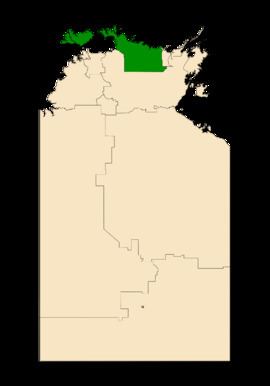 | ||
Area 156,087 km (60,265.5 sq mi) | ||
Arafura is an electoral division of the Legislative Assembly in Australia's Northern Territory. It was first created in 1983, and takes its name from the Arafura Sea, which adjoins the electorate. The electorate is predominantly rural, encompassing 156,087 square kilometres (60,266 square miles) in western Arnhem Land and the Tiwi Islands, and including the towns of Oenpelli, Jabiru, Maningrida, Milikapiti and Nguiu. There were 5,477 people enrolled in the electorate as of August 2012.
Background
Arafura was a safe seat for the Australian Labor Party from its inception until 2012, when the seat was won by the Country Liberal Party in a 15 per cent swing. However, Labor regained it as part of its massive victory in 2016. The electorate has a particularly high indigenous population, which has been reflected in its having been represented by five consecutive indigenous MPs.